You are here: Home > Network List > TA - USArray Transportable Network (new EarthScope stations) Stations List
> Station TCOL CIGO, UAF Yankovich Road, Fairbanks, AK, USA > Earthquake Result Viewer
TCOL CIGO, UAF Yankovich Road, Fairbanks, AK, USA - Earthquake Result Viewer
| Earthquake location: |
Vanuatu Islands |
| Earthquake latitude/longitude: |
-14.0/166.6 |
| Earthquake time(UTC): |
2016/04/07 (098) 03:32:53 GMT |
| Earthquake Depth: |
27 km |
| Earthquake Magnitude: |
6.7 MWW, 6.5 MWB, 6.9 MI |
| Earthquake Catalog/Contributor: |
NEIC PDE/NEIC COMCAT |
|
| Network: |
TA USArray Transportable Network (new EarthScope stations) |
| Station: |
TCOL CIGO, UAF Yankovich Road, Fairbanks, AK, USA |
| Lat/Lon: |
64.87 N/147.86 W |
| Elevation: |
178 m |
|
| Distance: |
85.8 deg |
| Az: |
17.8 deg |
| Baz: |
224.027 deg |
| Ray Param: |
0.04445853 |
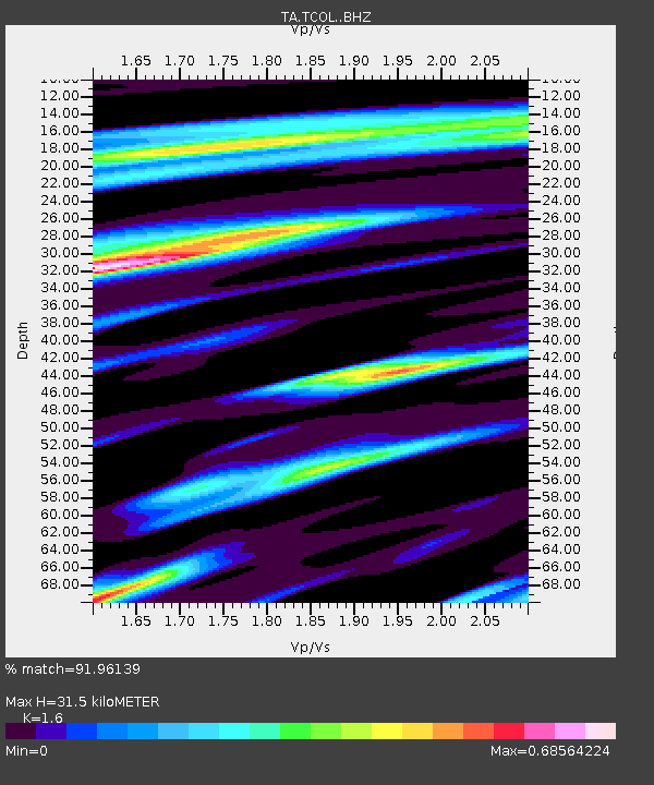
| Estimated Moho Depth: |
31.5 km |
| Estimated Crust Vp/Vs: |
1.60 |
| Assumed Crust Vp: |
6.566 km/s |
| Estimated Crust Vs: |
4.104 km/s |
| Estimated Crust Poisson's Ratio: |
0.18 |
|
| Radial Match: |
91.96139 % |
| Radial Bump: |
400 |
| Transverse Match: |
81.49471 % |
| Transverse Bump: |
400 |
| SOD ConfigId: |
7422571 |
| Insert Time: |
2019-04-22 04:22:56.897 +0000 |
| GWidth: |
2.5 |
| Max Bumps: |
400 |
| Tol: |
0.001 |
|

Signal To Noise
| Channel | StoN | STA | LTA |
| TA:TCOL: :BHZ:20160407T03:44:58.974998Z | 12.138781 | 1.8813766E-6 | 1.5498892E-7 |
| TA:TCOL: :BHN:20160407T03:44:58.974998Z | 3.6984632 | 5.766711E-7 | 1.5592181E-7 |
| TA:TCOL: :BHE:20160407T03:44:58.974998Z | 3.4749603 | 4.0848687E-7 | 1.1755152E-7 |
| Arrivals |
| Ps | 3.0 SECOND |
| PpPs | 12 SECOND |
| PsPs/PpSs | 15 SECOND |


