You are here: Home > Network List > UW - Pacific Northwest Regional Seismic Network Stations List
> Station WOLL Wollman Farm, Schrag, WA, USA > Earthquake Result Viewer
WOLL Wollman Farm, Schrag, WA, USA - Earthquake Result Viewer
| Earthquake location: |
Vanuatu Islands |
| Earthquake latitude/longitude: |
-14.0/166.6 |
| Earthquake time(UTC): |
2016/04/07 (098) 03:32:53 GMT |
| Earthquake Depth: |
27 km |
| Earthquake Magnitude: |
6.7 MWW, 6.5 MWB, 6.9 MI |
| Earthquake Catalog/Contributor: |
NEIC PDE/NEIC COMCAT |
|
| Network: |
UW Pacific Northwest Regional Seismic Network |
| Station: |
WOLL Wollman Farm, Schrag, WA, USA |
| Lat/Lon: |
47.06 N/118.92 W |
| Elevation: |
385 m |
|
| Distance: |
89.9 deg |
| Az: |
41.214 deg |
| Baz: |
249.298 deg |
| Ray Param: |
0.0417096 |
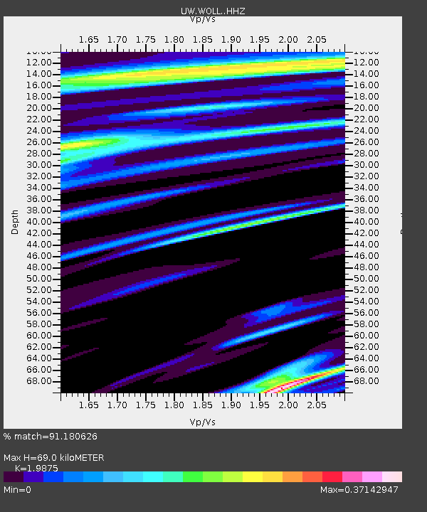
| Estimated Moho Depth: |
69.0 km |
| Estimated Crust Vp/Vs: |
1.99 |
| Assumed Crust Vp: |
6.419 km/s |
| Estimated Crust Vs: |
3.23 km/s |
| Estimated Crust Poisson's Ratio: |
0.33 |
|
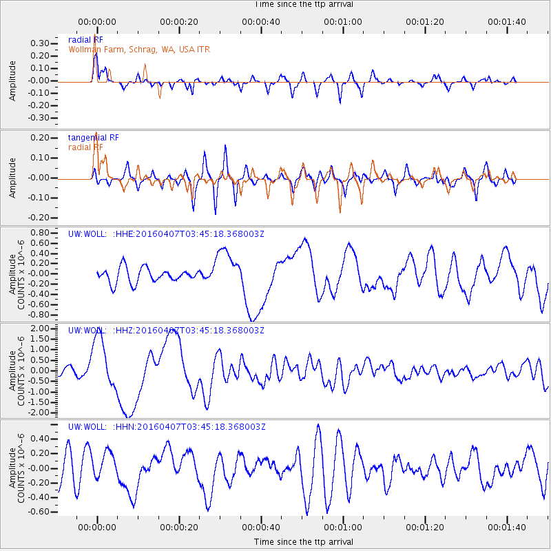
| Radial Match: |
91.180626 % |
| Radial Bump: |
365 |
| Transverse Match: |
65.923004 % |
| Transverse Bump: |
331 |
| SOD ConfigId: |
7422571 |
| Insert Time: |
2019-04-22 04:23:48.227 +0000 |
| GWidth: |
2.5 |
| Max Bumps: |
400 |
| Tol: |
0.001 |
|
Signal To Noise
| Channel | StoN | STA | LTA |
| UW:WOLL: :HHZ:20160407T03:45:18.368003Z | 10.412016 | 1.2811927E-6 | 1.2304945E-7 |
| UW:WOLL: :HHN:20160407T03:45:18.368003Z | 0.9102545 | 1.8382522E-7 | 2.0194926E-7 |
| UW:WOLL: :HHE:20160407T03:45:18.368003Z | 2.6849854 | 3.8288078E-7 | 1.426007E-7 |
| Arrivals |
| Ps | 11 SECOND |
| PpPs | 32 SECOND |
| PsPs/PpSs | 42 SECOND |


