You are here: Home > Network List > XD14 - Illuminating the architecture of the greater Mount St. Helens magmatic systems f Stations List
> Station MG06 "Mount St Helens, WA" > Earthquake Result Viewer
MG06 "Mount St Helens, WA" - Earthquake Result Viewer
| Earthquake location: |
Vanuatu Islands |
| Earthquake latitude/longitude: |
-14.0/166.6 |
| Earthquake time(UTC): |
2016/04/07 (098) 03:32:53 GMT |
| Earthquake Depth: |
27 km |
| Earthquake Magnitude: |
6.7 MWW, 6.5 MWB, 6.9 MI |
| Earthquake Catalog/Contributor: |
NEIC PDE/NEIC COMCAT |
|
| Network: |
XD Illuminating the architecture of the greater Mount St. Helens magmatic systems f |
| Station: |
MG06 "Mount St Helens, WA" |
| Lat/Lon: |
46.35 N/122.22 W |
| Elevation: |
1408 m |
|
| Distance: |
87.5 deg |
| Az: |
41.024 deg |
| Baz: |
246.902 deg |
| Ray Param: |
0.04323694 |
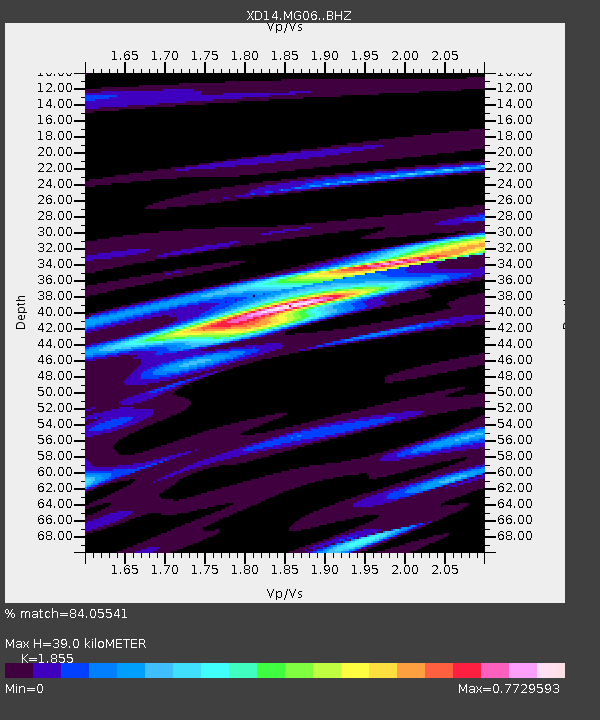
| Estimated Moho Depth: |
39.0 km |
| Estimated Crust Vp/Vs: |
1.86 |
| Assumed Crust Vp: |
6.566 km/s |
| Estimated Crust Vs: |
3.54 km/s |
| Estimated Crust Poisson's Ratio: |
0.30 |
|
| Radial Match: |
84.05541 % |
| Radial Bump: |
366 |
| Transverse Match: |
76.847496 % |
| Transverse Bump: |
400 |
| SOD ConfigId: |
7422571 |
| Insert Time: |
2019-04-22 04:24:04.415 +0000 |
| GWidth: |
2.5 |
| Max Bumps: |
400 |
| Tol: |
0.001 |
|

Signal To Noise
| Channel | StoN | STA | LTA |
| XD:MG06: :BHZ:20160407T03:45:07.224998Z | 10.738333 | 1.7163762E-6 | 1.5983638E-7 |
| XD:MG06: :BHN:20160407T03:45:07.224998Z | 1.5759376 | 2.0619841E-7 | 1.3084173E-7 |
| XD:MG06: :BHE:20160407T03:45:07.224998Z | 3.0104156 | 7.3600216E-7 | 2.4448525E-7 |
| Arrivals |
| Ps | 5.2 SECOND |
| PpPs | 17 SECOND |
| PsPs/PpSs | 22 SECOND |


