You are here: Home > Network List > US - United States National Seismic Network Stations List
> Station MIAR Mount Ida, Arkansas, USA > Earthquake Result Viewer
MIAR Mount Ida, Arkansas, USA - Earthquake Result Viewer
| Earthquake location: |
Samoa Islands Region |
| Earthquake latitude/longitude: |
-16.6/-172.0 |
| Earthquake time(UTC): |
2006/09/28 (271) 06:22:09 GMT |
| Earthquake Depth: |
28 km |
| Earthquake Magnitude: |
6.5 MB, 6.6 MS, 6.9 MW, 6.7 MW |
| Earthquake Catalog/Contributor: |
WHDF/NEIC |
|
| Network: |
US United States National Seismic Network |
| Station: |
MIAR Mount Ida, Arkansas, USA |
| Lat/Lon: |
34.55 N/93.58 W |
| Elevation: |
207 m |
|
| Distance: |
90.1 deg |
| Az: |
53.974 deg |
| Baz: |
249.966 deg |
| Ray Param: |
0.04169417 |
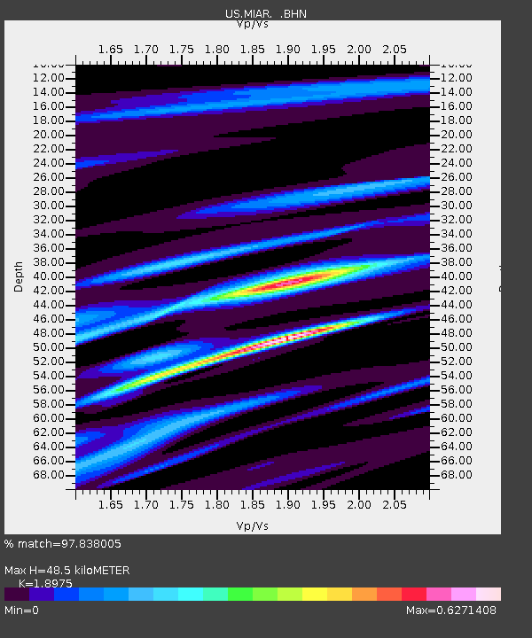
| Estimated Moho Depth: |
48.5 km |
| Estimated Crust Vp/Vs: |
1.90 |
| Assumed Crust Vp: |
6.498 km/s |
| Estimated Crust Vs: |
3.424 km/s |
| Estimated Crust Poisson's Ratio: |
0.31 |
|
| Radial Match: |
97.838005 % |
| Radial Bump: |
238 |
| Transverse Match: |
93.72172 % |
| Transverse Bump: |
358 |
| SOD ConfigId: |
2564 |
| Insert Time: |
2010-03-05 01:04:47.021 +0000 |
| GWidth: |
2.5 |
| Max Bumps: |
400 |
| Tol: |
0.001 |
|
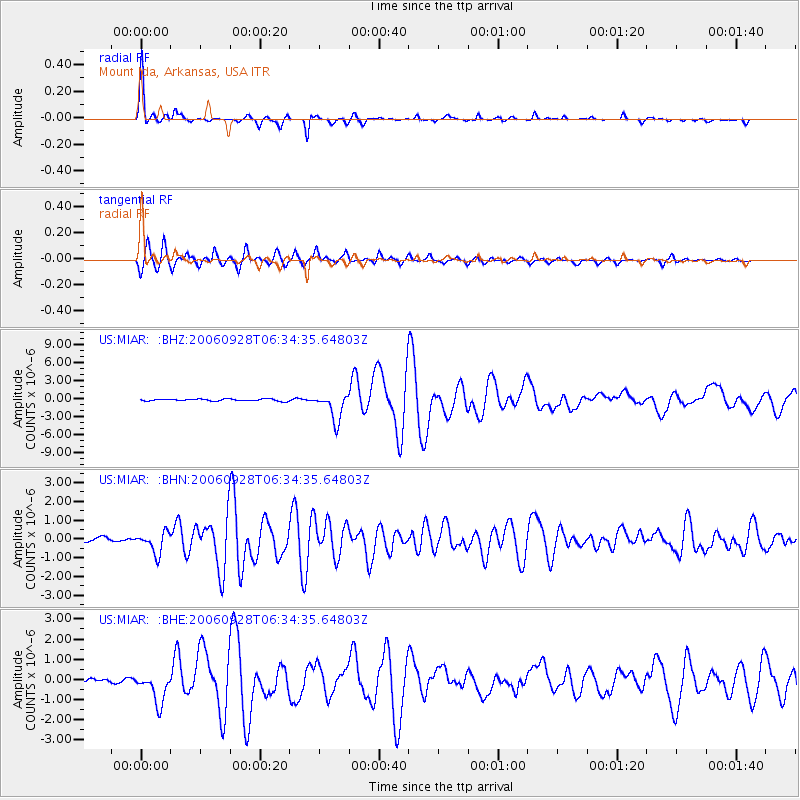
Signal To Noise
| Channel | StoN | STA | LTA |
| US:MIAR: :BHN:20060928T06:34:35.64803Z | 4.9681215 | 5.553901E-7 | 1.1179076E-7 |
| US:MIAR: :BHE:20060928T06:34:35.64803Z | 7.196344 | 7.49222E-7 | 1.0411148E-7 |
| US:MIAR: :BHZ:20060928T06:34:35.64803Z | 13.498062 | 2.2755291E-6 | 1.6858192E-7 |
| Arrivals |
| Ps | 6.8 SECOND |
| PpPs | 21 SECOND |
| PsPs/PpSs | 28 SECOND |


