You are here: Home > Network List > YT07 - POLENET Stations List
> Station FISH FISH > Earthquake Result Viewer
FISH FISH - Earthquake Result Viewer
| Earthquake location: |
Vanuatu Islands |
| Earthquake latitude/longitude: |
-14.0/166.6 |
| Earthquake time(UTC): |
2016/04/07 (098) 03:32:53 GMT |
| Earthquake Depth: |
27 km |
| Earthquake Magnitude: |
6.7 MWW, 6.5 MWB, 6.9 MI |
| Earthquake Catalog/Contributor: |
NEIC PDE/NEIC COMCAT |
|
| Network: |
YT POLENET |
| Station: |
FISH FISH |
| Lat/Lon: |
78.93 S/162.57 E |
| Elevation: |
273 m |
|
| Distance: |
65.0 deg |
| Az: |
180.854 deg |
| Baz: |
4.292 deg |
| Ray Param: |
0.058534812 |
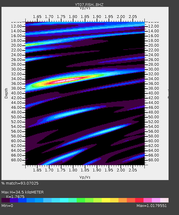
| Estimated Moho Depth: |
34.5 km |
| Estimated Crust Vp/Vs: |
1.77 |
| Assumed Crust Vp: |
6.43 km/s |
| Estimated Crust Vs: |
3.638 km/s |
| Estimated Crust Poisson's Ratio: |
0.26 |
|
| Radial Match: |
93.07025 % |
| Radial Bump: |
400 |
| Transverse Match: |
64.226845 % |
| Transverse Bump: |
400 |
| SOD ConfigId: |
7422571 |
| Insert Time: |
2019-04-22 04:25:54.030 +0000 |
| GWidth: |
2.5 |
| Max Bumps: |
400 |
| Tol: |
0.001 |
|

Signal To Noise
| Channel | StoN | STA | LTA |
| YT:FISH: :BHZ:20160407T03:42:59.949973Z | 4.3002973 | 2.2158094E-6 | 5.152689E-7 |
| YT:FISH: :BHN:20160407T03:42:59.949973Z | 4.822944 | 1.0254658E-6 | 2.1262238E-7 |
| YT:FISH: :BHE:20160407T03:42:59.949973Z | 2.0742424 | 6.006297E-7 | 2.895658E-7 |
| Arrivals |
| Ps | 4.3 SECOND |
| PpPs | 14 SECOND |
| PsPs/PpSs | 19 SECOND |


