MIAR Mount Ida, Arkansas, USA - Earthquake Result Viewer
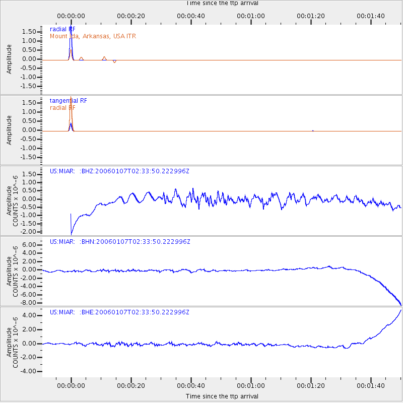
Earthquake location: Near Islands, Aleutian Islands
Earthquake latitude/longitude: 52.4/173.6
Earthquake time(UTC): 2006/01/07 (007) 02:23:43 GMT
Earthquake Depth: 31 km
Earthquake Magnitude: 5.7 MB, 4.9 MS, 5.5 MW, 5.5 MW
Earthquake Catalog/Contributor: WHDF/NEIC
Network: US United States National Seismic Network
Station: MIAR Mount Ida, Arkansas, USA
Lat/Lon: 34.55 N/93.58 W
Elevation: 207 m
Distance: 65.1 deg
Az: 65.384 deg
Baz: 317.577 deg
Ray Param: 0.058461398
Estimated Moho Depth: 10.0 km
Estimated Crust Vp/Vs: 1.60
Assumed Crust Vp: 6.498 km/s
Estimated Crust Vs: 4.061 km/s
Estimated Crust Poisson's Ratio: 0.18
Radial Match: 99.96134 %
Radial Bump: 4
Transverse Match: 99.87227 %
Transverse Bump: 11
SOD ConfigId: 2669
Insert Time: 2010-03-05 01:05:33.989 +0000
GWidth: 2.5
Max Bumps: 400
Tol: 0.001

Signal To Noise

ChannelStoNSTALTA
US:MIAR: :BHN:20060107T02:33:50.222996Z0.91251856.3155693E-76.921031E-7
US:MIAR: :BHE:20060107T02:33:50.222996Z0.914467333.6736947E-74.0173055E-7
US:MIAR: :BHZ:20060107T02:33:50.222996Z0.970640665.3681674E-75.53054E-7
Arrivals
Ps1.0 SECOND
PpPs3.8 SECOND
PsPs/PpSs4.8 SECOND