You are here: Home > Network List > TJ - Tajikistan National Seismic Network Stations List
> Station GARM Garm, Tajikistan > Earthquake Result Viewer
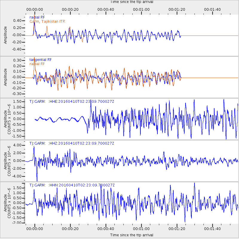
GARM Garm, Tajikistan - Earthquake Result Viewer
*The percent match for this event was below the threshold and hence no stack was calculated.
| Earthquake location: |
Southern Sumatra, Indonesia |
| Earthquake latitude/longitude: |
-4.1/102.3 |
| Earthquake time(UTC): |
2016/04/10 (101) 02:14:36 GMT |
| Earthquake Depth: |
55 km |
| Earthquake Magnitude: |
5.7 MWP |
| Earthquake Catalog/Contributor: |
NEIC PDE/NEIC COMCAT |
|
| Network: |
TJ Tajikistan National Seismic Network |
| Station: |
GARM Garm, Tajikistan |
| Lat/Lon: |
39.00 N/70.32 E |
| Elevation: |
1305 m |
|
| Distance: |
52.1 deg |
| Az: |
328.487 deg |
| Baz: |
138.005 deg |
| Ray Param: |
$rayparam |
*The percent match for this event was below the threshold and hence was not used in the summary stack. |
|
| Radial Match: |
55.478836 % |
| Radial Bump: |
400 |
| Transverse Match: |
57.339535 % |
| Transverse Bump: |
400 |
| SOD ConfigId: |
7422571 |
| Insert Time: |
2019-04-22 04:29:46.420 +0000 |
| GWidth: |
2.5 |
| Max Bumps: |
400 |
| Tol: |
0.001 |
|
Signal To Noise
| Channel | StoN | STA | LTA |
| TJ:GARM: :HHZ:20160410T02:23:09.700027Z | 15.486242 | 1.7478984E-6 | 1.12867816E-7 |
| TJ:GARM: :HHN:20160410T02:23:09.700027Z | 5.3246374 | 6.198477E-7 | 1.1641125E-7 |
| TJ:GARM: :HHE:20160410T02:23:09.700027Z | 6.3300953 | 6.57179E-7 | 1.0381819E-7 |
| Arrivals |
| Ps | |
| PpPs | |
| PsPs/PpSs | |


