You are here: Home > Network List > TJ - Tajikistan National Seismic Network Stations List
> Station MANEM Manem, Tajikistan > Earthquake Result Viewer
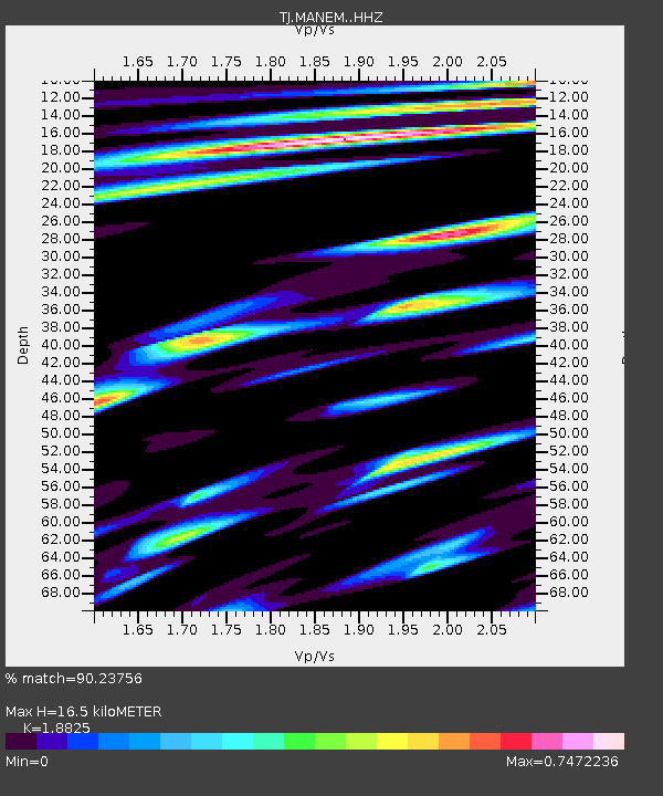
MANEM Manem, Tajikistan - Earthquake Result Viewer
| Earthquake location: |
Southern Sumatra, Indonesia |
| Earthquake latitude/longitude: |
-4.1/102.3 |
| Earthquake time(UTC): |
2016/04/10 (101) 02:14:36 GMT |
| Earthquake Depth: |
55 km |
| Earthquake Magnitude: |
5.7 MWP |
| Earthquake Catalog/Contributor: |
NEIC PDE/NEIC COMCAT |
|
| Network: |
TJ Tajikistan National Seismic Network |
| Station: |
MANEM Manem, Tajikistan |
| Lat/Lon: |
37.53 N/71.66 E |
| Elevation: |
2312 m |
|
| Distance: |
50.3 deg |
| Az: |
328.25 deg |
| Baz: |
138.685 deg |
| Ray Param: |
0.068005174 |
| Estimated Moho Depth: |
16.5 km |
| Estimated Crust Vp/Vs: |
1.88 |
| Assumed Crust Vp: |
6.306 km/s |
| Estimated Crust Vs: |
3.35 km/s |
| Estimated Crust Poisson's Ratio: |
0.30 |
|
| Radial Match: |
90.23756 % |
| Radial Bump: |
400 |
| Transverse Match: |
86.04772 % |
| Transverse Bump: |
400 |
| SOD ConfigId: |
7422571 |
| Insert Time: |
2019-04-22 04:29:47.885 +0000 |
| GWidth: |
2.5 |
| Max Bumps: |
400 |
| Tol: |
0.001 |
|

Signal To Noise
| Channel | StoN | STA | LTA |
| TJ:MANEM: :HHZ:20160410T02:22:56.229995Z | 40.25755 | 6.353524E-6 | 1.5782193E-7 |
| TJ:MANEM: :HHN:20160410T02:22:56.229995Z | 15.633241 | 2.8198172E-6 | 1.8037316E-7 |
| TJ:MANEM: :HHE:20160410T02:22:56.229995Z | 9.327178 | 2.0710934E-6 | 2.220493E-7 |
| Arrivals |
| Ps | 2.4 SECOND |
| PpPs | 7.2 SECOND |
| PsPs/PpSs | 9.6 SECOND |


