You are here: Home > Network List > XL12 - Hangay Dome, Mongolia Stations List
> Station HV02 HV02 > Earthquake Result Viewer
HV02 HV02 - Earthquake Result Viewer
| Earthquake location: |
Southern Sumatra, Indonesia |
| Earthquake latitude/longitude: |
-4.1/102.3 |
| Earthquake time(UTC): |
2016/04/10 (101) 02:14:36 GMT |
| Earthquake Depth: |
55 km |
| Earthquake Magnitude: |
5.7 MWP |
| Earthquake Catalog/Contributor: |
NEIC PDE/NEIC COMCAT |
|
| Network: |
XL Hangay Dome, Mongolia |
| Station: |
HV02 HV02 |
| Lat/Lon: |
51.15 N/99.35 E |
| Elevation: |
1546 m |
|
| Distance: |
55.1 deg |
| Az: |
357.759 deg |
| Baz: |
176.449 deg |
| Ray Param: |
0.06485397 |
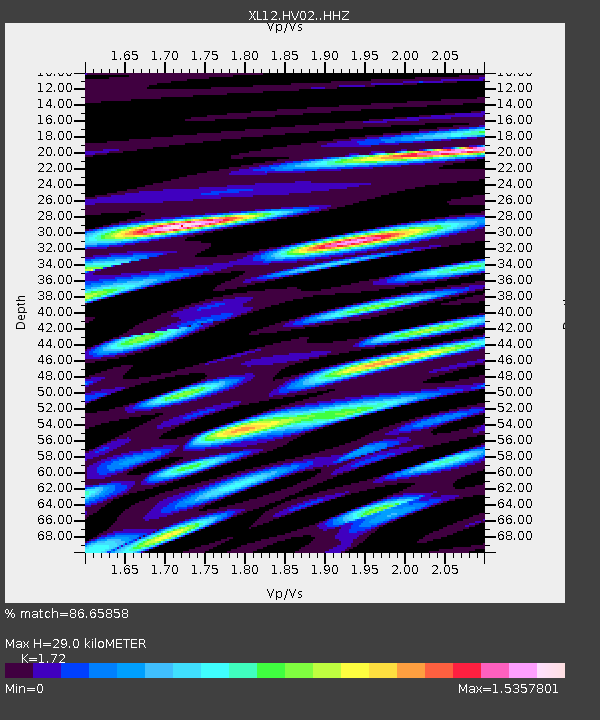
| Estimated Moho Depth: |
29.0 km |
| Estimated Crust Vp/Vs: |
1.72 |
| Assumed Crust Vp: |
6.622 km/s |
| Estimated Crust Vs: |
3.85 km/s |
| Estimated Crust Poisson's Ratio: |
0.24 |
|
| Radial Match: |
86.65858 % |
| Radial Bump: |
400 |
| Transverse Match: |
78.37346 % |
| Transverse Bump: |
400 |
| SOD ConfigId: |
7422571 |
| Insert Time: |
2019-04-22 04:30:06.812 +0000 |
| GWidth: |
2.5 |
| Max Bumps: |
400 |
| Tol: |
0.001 |
|

Signal To Noise
| Channel | StoN | STA | LTA |
| XL:HV02: :HHZ:20160410T02:23:32.149978Z | 27.400063 | 1.7407547E-6 | 6.353105E-8 |
| XL:HV02: :HHN:20160410T02:23:32.149978Z | 20.352331 | 9.4863674E-7 | 4.6610715E-8 |
| XL:HV02: :HHE:20160410T02:23:32.149978Z | 9.53426 | 6.632992E-7 | 6.957008E-8 |
| Arrivals |
| Ps | 3.3 SECOND |
| PpPs | 11 SECOND |
| PsPs/PpSs | 15 SECOND |


