You are here: Home > Network List > US - United States National Seismic Network Stations List
> Station MIAR Mount Ida, Arkansas, USA > Earthquake Result Viewer
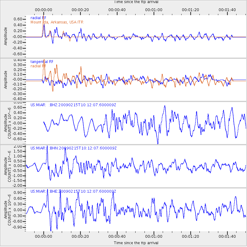
MIAR Mount Ida, Arkansas, USA - Earthquake Result Viewer
*The percent match for this event was below the threshold and hence no stack was calculated.
| Earthquake location: |
Near Coast Of Northern Peru |
| Earthquake latitude/longitude: |
-5.9/-80.9 |
| Earthquake time(UTC): |
2009/02/15 (046) 10:04:49 GMT |
| Earthquake Depth: |
21 km |
| Earthquake Magnitude: |
5.8 MB, 5.7 MS, 6.1 MW, 6.1 MW |
| Earthquake Catalog/Contributor: |
WHDF/NEIC |
|
| Network: |
US United States National Seismic Network |
| Station: |
MIAR Mount Ida, Arkansas, USA |
| Lat/Lon: |
34.55 N/93.58 W |
| Elevation: |
207 m |
|
| Distance: |
41.9 deg |
| Az: |
344.26 deg |
| Baz: |
160.917 deg |
| Ray Param: |
$rayparam |
*The percent match for this event was below the threshold and hence was not used in the summary stack. |
|
| Radial Match: |
64.39589 % |
| Radial Bump: |
400 |
| Transverse Match: |
70.83756 % |
| Transverse Bump: |
400 |
| SOD ConfigId: |
2658 |
| Insert Time: |
2010-03-05 01:06:05.430 +0000 |
| GWidth: |
2.5 |
| Max Bumps: |
400 |
| Tol: |
0.001 |
|
Signal To Noise
| Channel | StoN | STA | LTA |
| US:MIAR: :BHN:20090215T10:12:07.600009Z | 3.960012 | 8.2221294E-7 | 2.076289E-7 |
| US:MIAR: :BHE:20090215T10:12:07.600009Z | 2.4629362 | 5.099457E-7 | 2.0704789E-7 |
| US:MIAR: :BHZ:20090215T10:12:07.600009Z | 0.79147434 | 1.7067885E-7 | 2.1564672E-7 |
| Arrivals |
| Ps | |
| PpPs | |
| PsPs/PpSs | |


