You are here: Home > Network List > US - United States National Seismic Network Stations List
> Station MIAR Mount Ida, Arkansas, USA > Earthquake Result Viewer
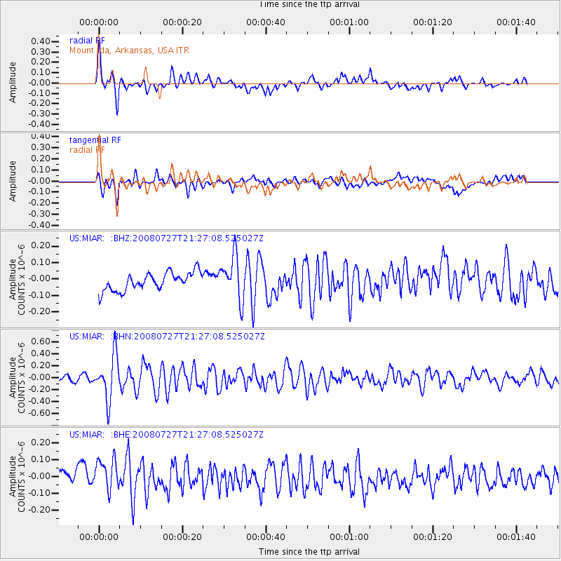
MIAR Mount Ida, Arkansas, USA - Earthquake Result Viewer
*The percent match for this event was below the threshold and hence no stack was calculated.
| Earthquake location: |
Central Mid-Atlantic Ridge |
| Earthquake latitude/longitude: |
-0.3/-18.3 |
| Earthquake time(UTC): |
2008/07/27 (209) 21:15:41 GMT |
| Earthquake Depth: |
10 km |
| Earthquake Magnitude: |
5.8 MB, 5.3 MS, 5.9 MW, 5.8 MW |
| Earthquake Catalog/Contributor: |
WHDF/NEIC |
|
| Network: |
US United States National Seismic Network |
| Station: |
MIAR Mount Ida, Arkansas, USA |
| Lat/Lon: |
34.55 N/93.58 W |
| Elevation: |
207 m |
|
| Distance: |
78.0 deg |
| Az: |
305.307 deg |
| Baz: |
98.649 deg |
| Ray Param: |
$rayparam |
*The percent match for this event was below the threshold and hence was not used in the summary stack. |
|
| Radial Match: |
73.712265 % |
| Radial Bump: |
400 |
| Transverse Match: |
42.80136 % |
| Transverse Bump: |
400 |
| SOD ConfigId: |
2504 |
| Insert Time: |
2010-03-05 01:06:12.817 +0000 |
| GWidth: |
2.5 |
| Max Bumps: |
400 |
| Tol: |
0.001 |
|
Signal To Noise
| Channel | StoN | STA | LTA |
| US:MIAR: :BHN:20080727T21:27:08.525027Z | 6.9985595 | 3.8356933E-7 | 5.4806897E-8 |
| US:MIAR: :BHE:20080727T21:27:08.525027Z | 1.6096323 | 1.179589E-7 | 7.328314E-8 |
| US:MIAR: :BHZ:20080727T21:27:08.525027Z | 2.5564582 | 1.3871222E-7 | 5.4259527E-8 |
| Arrivals |
| Ps | |
| PpPs | |
| PsPs/PpSs | |


