You are here: Home > Network List > CI - Caltech Regional Seismic Network Stations List
> Station BAR Barrett, Tecate, CA, USA > Earthquake Result Viewer
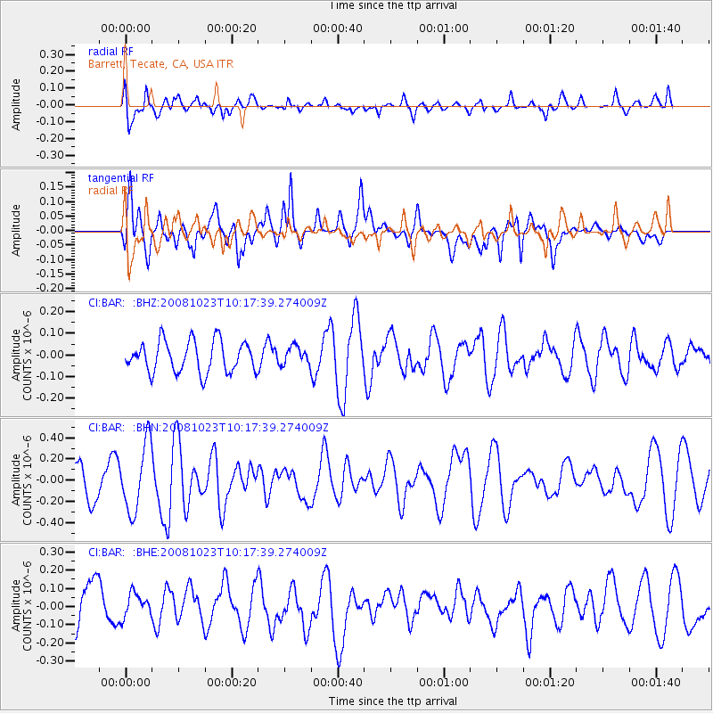
BAR Barrett, Tecate, CA, USA - Earthquake Result Viewer
*The percent match for this event was below the threshold and hence no stack was calculated.
| Earthquake location: |
Admiralty Islands Region, P.N.G. |
| Earthquake latitude/longitude: |
-2.6/145.6 |
| Earthquake time(UTC): |
2008/10/23 (297) 10:04:35 GMT |
| Earthquake Depth: |
10 km |
| Earthquake Magnitude: |
6.0 MB, 6.3 MS, 6.3 MW, 6.3 MW |
| Earthquake Catalog/Contributor: |
WHDF/NEIC |
|
| Network: |
CI Caltech Regional Seismic Network |
| Station: |
BAR Barrett, Tecate, CA, USA |
| Lat/Lon: |
32.68 N/116.67 W |
| Elevation: |
521 m |
|
| Distance: |
97.9 deg |
| Az: |
57.536 deg |
| Baz: |
271.962 deg |
| Ray Param: |
$rayparam |
*The percent match for this event was below the threshold and hence was not used in the summary stack. |
|
| Radial Match: |
58.744568 % |
| Radial Bump: |
400 |
| Transverse Match: |
54.123814 % |
| Transverse Bump: |
400 |
| SOD ConfigId: |
2556 |
| Insert Time: |
2010-02-26 00:12:58.182 +0000 |
| GWidth: |
2.5 |
| Max Bumps: |
400 |
| Tol: |
0.001 |
|
Signal To Noise
| Channel | StoN | STA | LTA |
| CI:BAR: :BHN:20081023T10:17:39.274009Z | 2.5489864 | 3.2080348E-7 | 1.2585531E-7 |
| CI:BAR: :BHE:20081023T10:17:39.274009Z | 0.54812455 | 7.2199775E-8 | 1.3172148E-7 |
| CI:BAR: :BHZ:20081023T10:17:39.274009Z | 0.5818619 | 4.175343E-8 | 7.1758315E-8 |
| Arrivals |
| Ps | |
| PpPs | |
| PsPs/PpSs | |


