You are here: Home > Network List > US - United States National Seismic Network Stations List
> Station GLMI Grayling, Michigan, USA > Earthquake Result Viewer
GLMI Grayling, Michigan, USA - Earthquake Result Viewer

| Earthquake location: |
Fox Islands, Aleutian Islands |
| Earthquake latitude/longitude: |
52.4/-169.7 |
| Earthquake time(UTC): |
2015/07/27 (208) 04:49:44 GMT |
| Earthquake Depth: |
12 km |
| Earthquake Magnitude: |
6.9 MO |
| Earthquake Catalog/Contributor: |
NEIC PDE/NEIC ALERT |
|
| Network: |
US United States National Seismic Network |
| Station: |
GLMI Grayling, Michigan, USA |
| Lat/Lon: |
44.82 N/84.62 W |
| Elevation: |
387 m |
|
| Distance: |
53.6 deg |
| Az: |
61.678 deg |
| Baz: |
310.682 deg |
| Ray Param: |
0.06595531 |
| Estimated Moho Depth: |
20.0 km |
| Estimated Crust Vp/Vs: |
1.69 |
| Assumed Crust Vp: |
6.483 km/s |
| Estimated Crust Vs: |
3.847 km/s |
| Estimated Crust Poisson's Ratio: |
0.23 |
|
| Radial Match: |
93.200615 % |
| Radial Bump: |
400 |
| Transverse Match: |
84.07894 % |
| Transverse Bump: |
400 |
| SOD ConfigId: |
1085051 |
| Insert Time: |
2015-08-10 05:19:57.131 +0000 |
| GWidth: |
2.5 |
| Max Bumps: |
400 |
| Tol: |
0.001 |
|
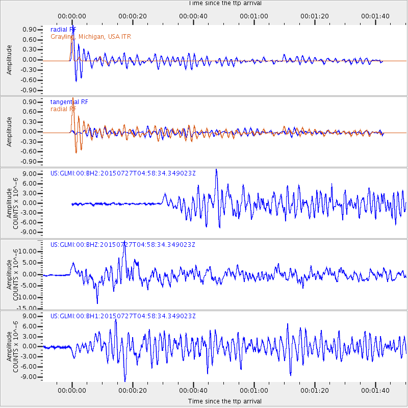
Signal To Noise
| Channel | StoN | STA | LTA |
| US:GLMI:00:BHZ:20150727T04:58:34.349023Z | 21.542078 | 2.5604847E-6 | 1.1885969E-7 |
| US:GLMI:00:BH1:20150727T04:58:34.349023Z | 6.932155 | 1.3359864E-6 | 1.927231E-7 |
| US:GLMI:00:BH2:20150727T04:58:34.349023Z | 8.079239 | 1.3008703E-6 | 1.6101397E-7 |
| Arrivals |
| Ps | 2.2 SECOND |
| PpPs | 7.8 SECOND |
| PsPs/PpSs | 10 SECOND |


