You are here: Home > Network List > ZQ15 - Taku Glacier Stations List
> Station GUGU Taku Glacier, Alaska, USA > Earthquake Result Viewer
GUGU Taku Glacier, Alaska, USA - Earthquake Result Viewer
| Earthquake location: |
Oaxaca, Mexico |
| Earthquake latitude/longitude: |
16.1/-96.3 |
| Earthquake time(UTC): |
2016/04/10 (101) 07:11:21 GMT |
| Earthquake Depth: |
25 km |
| Earthquake Magnitude: |
5.5 MWW, 5.2 MWB, 5.5 MWC |
| Earthquake Catalog/Contributor: |
NEIC PDE/NEIC COMCAT |
|
| Network: |
ZQ Taku Glacier |
| Station: |
GUGU Taku Glacier, Alaska, USA |
| Lat/Lon: |
58.42 N/134.04 W |
| Elevation: |
139 m |
|
| Distance: |
50.7 deg |
| Az: |
335.371 deg |
| Baz: |
130.411 deg |
| Ray Param: |
0.067850605 |
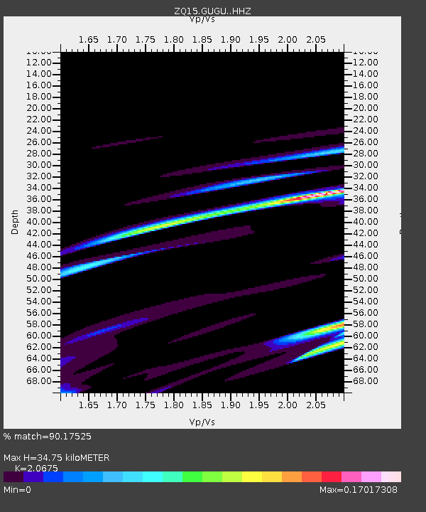
| Estimated Moho Depth: |
34.75 km |
| Estimated Crust Vp/Vs: |
2.07 |
| Assumed Crust Vp: |
6.566 km/s |
| Estimated Crust Vs: |
3.176 km/s |
| Estimated Crust Poisson's Ratio: |
0.35 |
|
| Radial Match: |
90.17525 % |
| Radial Bump: |
271 |
| Transverse Match: |
50.17452 % |
| Transverse Bump: |
400 |
| SOD ConfigId: |
7422571 |
| Insert Time: |
2019-04-22 04:37:05.745 +0000 |
| GWidth: |
2.5 |
| Max Bumps: |
400 |
| Tol: |
0.001 |
|

Signal To Noise
| Channel | StoN | STA | LTA |
| ZQ:GUGU: :HHZ:20160410T07:19:48.039991Z | 0.62412226 | 1.8719321E-7 | 2.9993032E-7 |
| ZQ:GUGU: :HH1:20160410T07:19:48.039991Z | 0.8533663 | 3.5164962E-7 | 4.120735E-7 |
| ZQ:GUGU: :HH2:20160410T07:19:48.039991Z | 0.65867007 | 2.3795582E-7 | 3.6126707E-7 |
| Arrivals |
| Ps | 5.9 SECOND |
| PpPs | 15 SECOND |
| PsPs/PpSs | 21 SECOND |


