You are here: Home > Network List > AK - Alaska Regional Network Stations List
> Station CUT Chulitna, AK, USA > Earthquake Result Viewer
CUT Chulitna, AK, USA - Earthquake Result Viewer
| Earthquake location: |
Afghanistan-Tajikistan Bord Reg. |
| Earthquake latitude/longitude: |
36.5/71.2 |
| Earthquake time(UTC): |
2016/04/10 (101) 10:28:58 GMT |
| Earthquake Depth: |
210 km |
| Earthquake Magnitude: |
6.6 MWB |
| Earthquake Catalog/Contributor: |
NEIC PDE/NEIC COMCAT |
|
| Network: |
AK Alaska Regional Network |
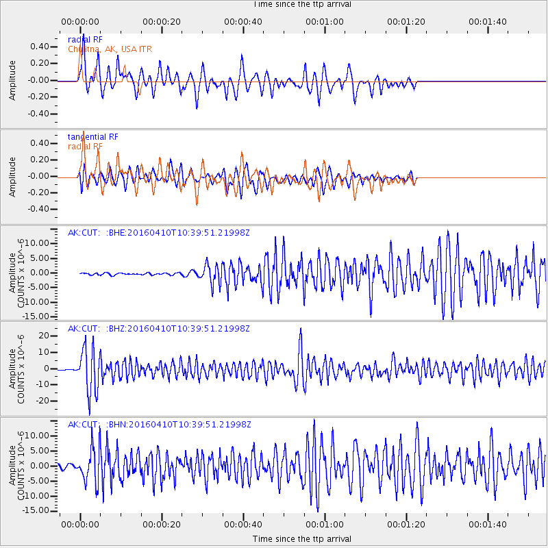
| Station: |
CUT Chulitna, AK, USA |
| Lat/Lon: |
62.41 N/150.26 W |
| Elevation: |
574 m |
|
| Distance: |
76.0 deg |
| Az: |
18.514 deg |
| Baz: |
326.665 deg |
| Ray Param: |
0.050765384 |
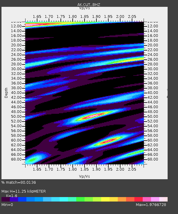
| Estimated Moho Depth: |
11.25 km |
| Estimated Crust Vp/Vs: |
1.60 |
| Assumed Crust Vp: |
6.438 km/s |
| Estimated Crust Vs: |
4.024 km/s |
| Estimated Crust Poisson's Ratio: |
0.18 |
|
| Radial Match: |
80.0136 % |
| Radial Bump: |
303 |
| Transverse Match: |
79.064896 % |
| Transverse Bump: |
367 |
| SOD ConfigId: |
7422571 |
| Insert Time: |
2019-04-22 04:38:10.371 +0000 |
| GWidth: |
2.5 |
| Max Bumps: |
400 |
| Tol: |
0.001 |
|
Signal To Noise
| Channel | StoN | STA | LTA |
| AK:CUT: :BHZ:20160410T10:39:51.21998Z | 52.056423 | 1.3378348E-5 | 2.5699705E-7 |
| AK:CUT: :BHN:20160410T10:39:51.21998Z | 8.294192 | 5.73831E-6 | 6.918467E-7 |
| AK:CUT: :BHE:20160410T10:39:51.21998Z | 10.002782 | 3.1835875E-6 | 3.182702E-7 |
| Arrivals |
| Ps | 1.1 SECOND |
| PpPs | 4.4 SECOND |
| PsPs/PpSs | 5.5 SECOND |


