You are here: Home > Network List > US - United States National Seismic Network Stations List
> Station MIAR Mount Ida, Arkansas, USA > Earthquake Result Viewer
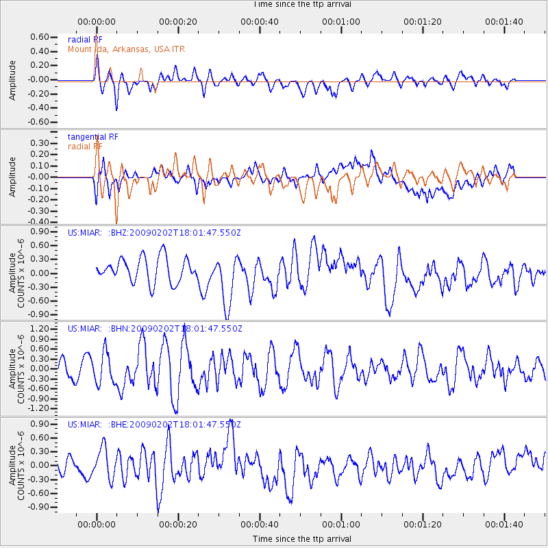
MIAR Mount Ida, Arkansas, USA - Earthquake Result Viewer
*The percent match for this event was below the threshold and hence no stack was calculated.
| Earthquake location: |
Near Coast Of Peru |
| Earthquake latitude/longitude: |
-13.6/-76.6 |
| Earthquake time(UTC): |
2009/02/02 (033) 17:53:21 GMT |
| Earthquake Depth: |
21 km |
| Earthquake Magnitude: |
5.6 MB, 5.6 MS, 6.0 MW, 5.9 MW |
| Earthquake Catalog/Contributor: |
WHDF/NEIC |
|
| Network: |
US United States National Seismic Network |
| Station: |
MIAR Mount Ida, Arkansas, USA |
| Lat/Lon: |
34.55 N/93.58 W |
| Elevation: |
207 m |
|
| Distance: |
50.5 deg |
| Az: |
341.76 deg |
| Baz: |
158.363 deg |
| Ray Param: |
$rayparam |
*The percent match for this event was below the threshold and hence was not used in the summary stack. |
|
| Radial Match: |
47.527363 % |
| Radial Bump: |
400 |
| Transverse Match: |
47.034164 % |
| Transverse Bump: |
400 |
| SOD ConfigId: |
6627 |
| Insert Time: |
2010-03-05 01:06:54.218 +0000 |
| GWidth: |
2.5 |
| Max Bumps: |
400 |
| Tol: |
0.001 |
|
Signal To Noise
| Channel | StoN | STA | LTA |
| US:MIAR: :BHN:20090202T18:01:47.550Z | 1.2459589 | 4.7287355E-7 | 3.795258E-7 |
| US:MIAR: :BHE:20090202T18:01:47.550Z | 1.054352 | 3.6462205E-7 | 3.458257E-7 |
| US:MIAR: :BHZ:20090202T18:01:47.550Z | 2.1640882 | 5.673305E-7 | 2.6215682E-7 |
| Arrivals |
| Ps | |
| PpPs | |
| PsPs/PpSs | |


