You are here: Home > Network List > US - United States National Seismic Network Stations List
> Station MIAR Mount Ida, Arkansas, USA > Earthquake Result Viewer
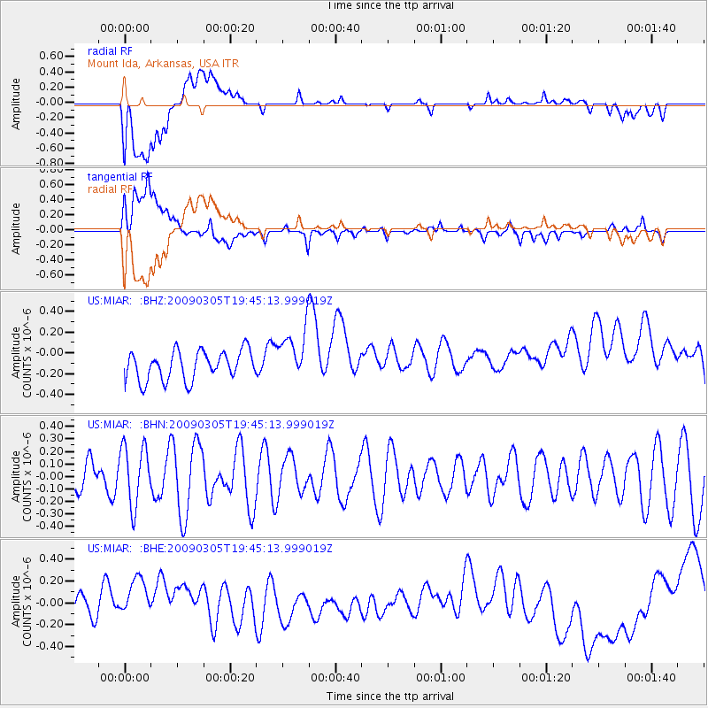
MIAR Mount Ida, Arkansas, USA - Earthquake Result Viewer
*The percent match for this event was below the threshold and hence no stack was calculated.
| Earthquake location: |
Fiji Islands Region |
| Earthquake latitude/longitude: |
-17.5/-179.1 |
| Earthquake time(UTC): |
2009/03/05 (064) 19:33:14 GMT |
| Earthquake Depth: |
532 km |
| Earthquake Magnitude: |
5.9 MW, 5.4 MB, 5.8 MW |
| Earthquake Catalog/Contributor: |
WHDF/NEIC |
|
| Network: |
US United States National Seismic Network |
| Station: |
MIAR Mount Ida, Arkansas, USA |
| Lat/Lon: |
34.55 N/93.58 W |
| Elevation: |
207 m |
|
| Distance: |
96.1 deg |
| Az: |
55.854 deg |
| Baz: |
253.083 deg |
| Ray Param: |
$rayparam |
*The percent match for this event was below the threshold and hence was not used in the summary stack. |
|
| Radial Match: |
22.922312 % |
| Radial Bump: |
400 |
| Transverse Match: |
36.165276 % |
| Transverse Bump: |
400 |
| SOD ConfigId: |
2658 |
| Insert Time: |
2010-03-05 01:07:26.304 +0000 |
| GWidth: |
2.5 |
| Max Bumps: |
400 |
| Tol: |
0.001 |
|
Signal To Noise
| Channel | StoN | STA | LTA |
| US:MIAR: :BHN:20090305T19:45:13.999019Z | 1.8187339 | 2.4174807E-7 | 1.3292107E-7 |
| US:MIAR: :BHE:20090305T19:45:13.999019Z | 1.9768578 | 2.8845113E-7 | 1.4591394E-7 |
| US:MIAR: :BHZ:20090305T19:45:13.999019Z | 1.854452 | 2.5806415E-7 | 1.3915924E-7 |
| Arrivals |
| Ps | |
| PpPs | |
| PsPs/PpSs | |


