You are here: Home > Network List > CN - Canadian National Seismograph Network Stations List
> Station DRLN Deer Lake, NFLD. > Earthquake Result Viewer
DRLN Deer Lake, NFLD. - Earthquake Result Viewer
| Earthquake location: |
Afghanistan-Tajikistan Bord Reg. |
| Earthquake latitude/longitude: |
36.5/71.2 |
| Earthquake time(UTC): |
2016/04/10 (101) 10:28:58 GMT |
| Earthquake Depth: |
210 km |
| Earthquake Magnitude: |
6.6 MWB |
| Earthquake Catalog/Contributor: |
NEIC PDE/NEIC COMCAT |
|
| Network: |
CN Canadian National Seismograph Network |
| Station: |
DRLN Deer Lake, NFLD. |
| Lat/Lon: |
49.26 N/57.50 W |
| Elevation: |
238 m |
|
| Distance: |
83.3 deg |
| Az: |
328.99 deg |
| Baz: |
39.319 deg |
| Ray Param: |
0.045803025 |
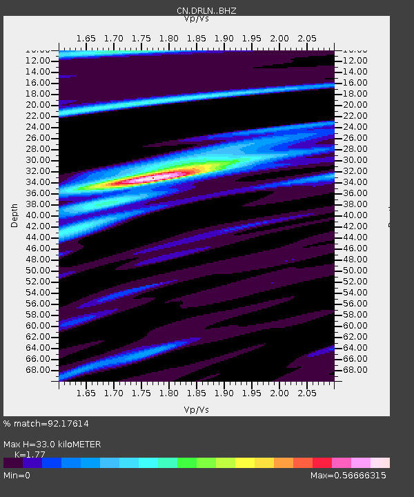
| Estimated Moho Depth: |
33.0 km |
| Estimated Crust Vp/Vs: |
1.77 |
| Assumed Crust Vp: |
6.35 km/s |
| Estimated Crust Vs: |
3.588 km/s |
| Estimated Crust Poisson's Ratio: |
0.27 |
|
| Radial Match: |
92.17614 % |
| Radial Bump: |
207 |
| Transverse Match: |
81.1971 % |
| Transverse Bump: |
292 |
| SOD ConfigId: |
7422571 |
| Insert Time: |
2019-04-22 04:40:18.809 +0000 |
| GWidth: |
2.5 |
| Max Bumps: |
400 |
| Tol: |
0.001 |
|

Signal To Noise
| Channel | StoN | STA | LTA |
| CN:DRLN: :BHZ:20160410T10:40:30.174998Z | 15.585399 | 9.383911E-6 | 6.020963E-7 |
| CN:DRLN: :BHN:20160410T10:40:30.174998Z | 8.382607 | 2.2317704E-6 | 2.662382E-7 |
| CN:DRLN: :BHE:20160410T10:40:30.174998Z | 4.4067607 | 1.204115E-6 | 2.7324268E-7 |
| Arrivals |
| Ps | 4.1 SECOND |
| PpPs | 14 SECOND |
| PsPs/PpSs | 18 SECOND |


