You are here: Home > Network List > DK - Danish Seismological Network Stations List
> Station DBG Daneborg, Greenland > Earthquake Result Viewer
DBG Daneborg, Greenland - Earthquake Result Viewer
| Earthquake location: |
Afghanistan-Tajikistan Bord Reg. |
| Earthquake latitude/longitude: |
36.5/71.2 |
| Earthquake time(UTC): |
2016/04/10 (101) 10:28:58 GMT |
| Earthquake Depth: |
210 km |
| Earthquake Magnitude: |
6.6 MWB |
| Earthquake Catalog/Contributor: |
NEIC PDE/NEIC COMCAT |
|
| Network: |
DK Danish Seismological Network |
| Station: |
DBG Daneborg, Greenland |
| Lat/Lon: |
74.31 N/20.22 W |
| Elevation: |
1.0 m |
|
| Distance: |
55.6 deg |
| Az: |
340.753 deg |
| Baz: |
77.42 deg |
| Ray Param: |
0.06394866 |
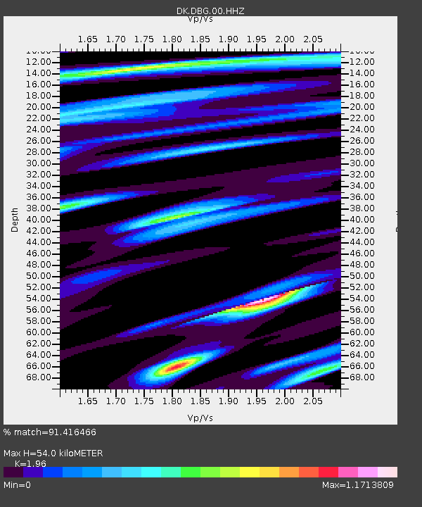
| Estimated Moho Depth: |
54.0 km |
| Estimated Crust Vp/Vs: |
1.96 |
| Assumed Crust Vp: |
6.459 km/s |
| Estimated Crust Vs: |
3.296 km/s |
| Estimated Crust Poisson's Ratio: |
0.32 |
|
| Radial Match: |
91.416466 % |
| Radial Bump: |
400 |
| Transverse Match: |
87.56416 % |
| Transverse Bump: |
400 |
| SOD ConfigId: |
7422571 |
| Insert Time: |
2019-04-22 04:41:20.129 +0000 |
| GWidth: |
2.5 |
| Max Bumps: |
400 |
| Tol: |
0.001 |
|

Signal To Noise
| Channel | StoN | STA | LTA |
| DK:DBG:00:HHZ:20160410T10:37:41.869028Z | 12.888992 | 6.754376E-6 | 5.2404226E-7 |
| DK:DBG:00:HH1:20160410T10:37:41.869028Z | 3.5590446 | 1.1465614E-6 | 3.2215428E-7 |
| DK:DBG:00:HH2:20160410T10:37:41.869028Z | 9.415661 | 3.0730387E-6 | 3.2637524E-7 |
| Arrivals |
| Ps | 8.4 SECOND |
| PpPs | 24 SECOND |
| PsPs/PpSs | 32 SECOND |


