You are here: Home > Network List > DK - Danish Seismological Network Stations List
> Station MUD Station Monsted Kalkmine, Denmark > Earthquake Result Viewer
MUD Station Monsted Kalkmine, Denmark - Earthquake Result Viewer
| Earthquake location: |
Afghanistan-Tajikistan Bord Reg. |
| Earthquake latitude/longitude: |
36.5/71.2 |
| Earthquake time(UTC): |
2016/04/10 (101) 10:28:58 GMT |
| Earthquake Depth: |
210 km |
| Earthquake Magnitude: |
6.6 MWB |
| Earthquake Catalog/Contributor: |
NEIC PDE/NEIC COMCAT |
|
| Network: |
DK Danish Seismological Network |
| Station: |
MUD Station Monsted Kalkmine, Denmark |
| Lat/Lon: |
56.46 N/9.17 E |
| Elevation: |
12 m |
|
| Distance: |
45.4 deg |
| Az: |
316.465 deg |
| Baz: |
88.881 deg |
| Ray Param: |
0.0705268 |
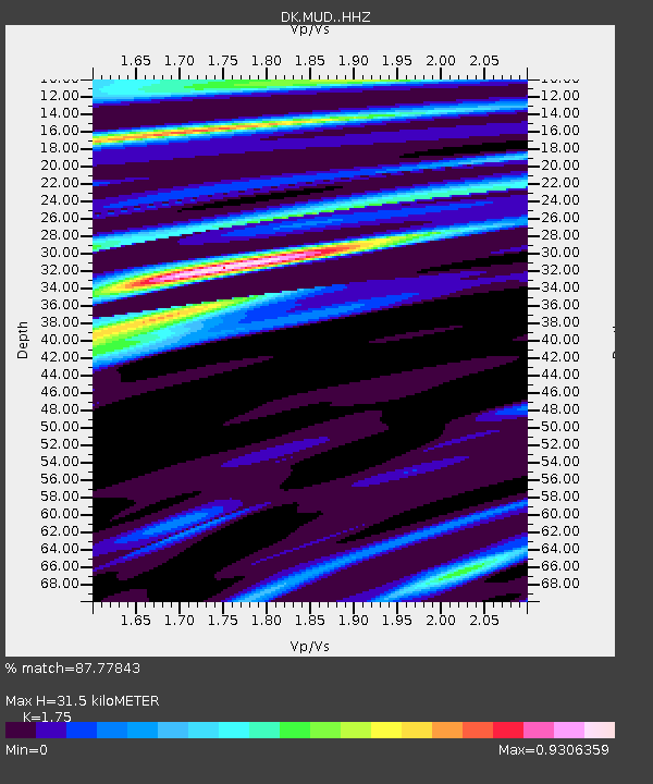
| Estimated Moho Depth: |
31.5 km |
| Estimated Crust Vp/Vs: |
1.75 |
| Assumed Crust Vp: |
6.159 km/s |
| Estimated Crust Vs: |
3.52 km/s |
| Estimated Crust Poisson's Ratio: |
0.26 |
|
| Radial Match: |
87.77843 % |
| Radial Bump: |
399 |
| Transverse Match: |
66.41425 % |
| Transverse Bump: |
400 |
| SOD ConfigId: |
7422571 |
| Insert Time: |
2019-04-22 04:41:24.526 +0000 |
| GWidth: |
2.5 |
| Max Bumps: |
400 |
| Tol: |
0.001 |
|

Signal To Noise
| Channel | StoN | STA | LTA |
| DK:MUD: :HHZ:20160410T10:36:25.186991Z | 18.328934 | 9.955736E-6 | 5.431705E-7 |
| DK:MUD: :HHN:20160410T10:36:25.186991Z | 2.2134573 | 1.2461044E-6 | 5.6296744E-7 |
| DK:MUD: :HHE:20160410T10:36:25.186991Z | 5.6502614 | 3.3084139E-6 | 5.8553286E-7 |
| Arrivals |
| Ps | 4.1 SECOND |
| PpPs | 13 SECOND |
| PsPs/PpSs | 17 SECOND |


