You are here: Home > Network List > CI - Caltech Regional Seismic Network Stations List
> Station BAR Barrett, Tecate, CA, USA > Earthquake Result Viewer
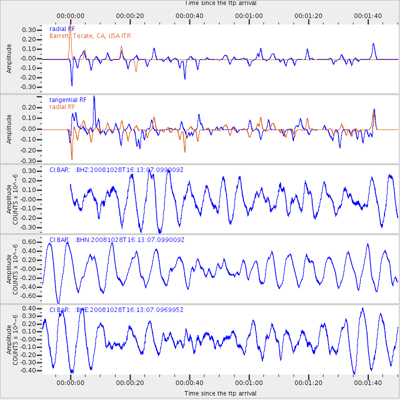
BAR Barrett, Tecate, CA, USA - Earthquake Result Viewer
*The percent match for this event was below the threshold and hence no stack was calculated.
| Earthquake location: |
Near N Coast Of New Guinea, P.N.G. |
| Earthquake latitude/longitude: |
-3.5/145.9 |
| Earthquake time(UTC): |
2008/10/28 (302) 16:00:03 GMT |
| Earthquake Depth: |
18 km |
| Earthquake Magnitude: |
5.5 MB, 5.9 MS, 6.0 MW, 6.0 MW |
| Earthquake Catalog/Contributor: |
WHDF/NEIC |
|
| Network: |
CI Caltech Regional Seismic Network |
| Station: |
BAR Barrett, Tecate, CA, USA |
| Lat/Lon: |
32.68 N/116.67 W |
| Elevation: |
521 m |
|
| Distance: |
98.2 deg |
| Az: |
57.644 deg |
| Baz: |
271.076 deg |
| Ray Param: |
$rayparam |
*The percent match for this event was below the threshold and hence was not used in the summary stack. |
|
| Radial Match: |
79.65613 % |
| Radial Bump: |
311 |
| Transverse Match: |
75.13826 % |
| Transverse Bump: |
400 |
| SOD ConfigId: |
2560 |
| Insert Time: |
2010-02-26 00:13:05.299 +0000 |
| GWidth: |
2.5 |
| Max Bumps: |
400 |
| Tol: |
0.001 |
|
Signal To Noise
| Channel | StoN | STA | LTA |
| CI:BAR: :BHN:20081028T16:13:07.099009Z | 1.130371 | 3.4593901E-7 | 3.0604025E-7 |
| CI:BAR: :BHE:20081028T16:13:07.096995Z | 2.5482213 | 3.0279563E-7 | 1.18826264E-7 |
| CI:BAR: :BHZ:20081028T16:13:07.099009Z | 1.7952042 | 2.4045622E-7 | 1.3394366E-7 |
| Arrivals |
| Ps | |
| PpPs | |
| PsPs/PpSs | |


