You are here: Home > Network List > GB - Great Britain Seismograph Network Stations List
> Station ELSH ELHAM, ENGLAND > Earthquake Result Viewer
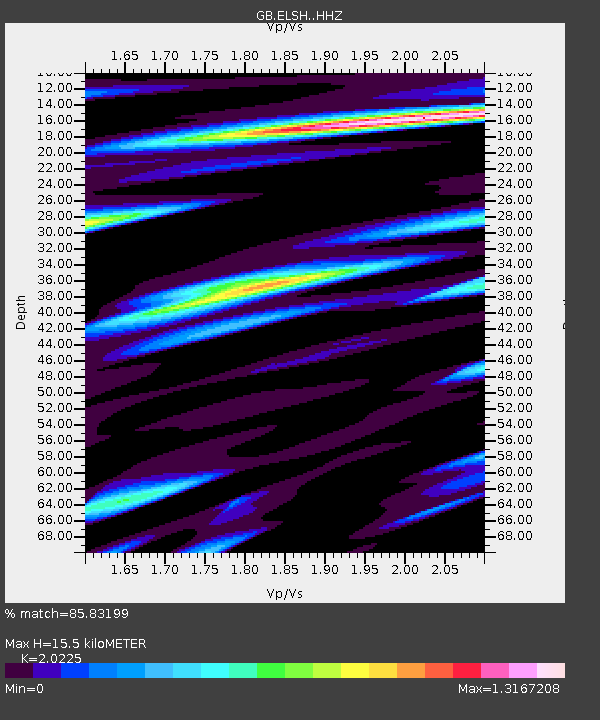
ELSH ELHAM, ENGLAND - Earthquake Result Viewer
| Earthquake location: |
Afghanistan-Tajikistan Bord Reg. |
| Earthquake latitude/longitude: |
36.5/71.2 |
| Earthquake time(UTC): |
2016/04/10 (101) 10:28:58 GMT |
| Earthquake Depth: |
210 km |
| Earthquake Magnitude: |
6.6 MWB |
| Earthquake Catalog/Contributor: |
NEIC PDE/NEIC COMCAT |
|
| Network: |
GB Great Britain Seismograph Network |
| Station: |
ELSH ELHAM, ENGLAND |
| Lat/Lon: |
51.15 N/1.14 E |
| Elevation: |
129 m |
|
| Distance: |
50.7 deg |
| Az: |
310.099 deg |
| Baz: |
78.136 deg |
| Ray Param: |
0.067121685 |
| Estimated Moho Depth: |
15.5 km |
| Estimated Crust Vp/Vs: |
2.02 |
| Assumed Crust Vp: |
6.207 km/s |
| Estimated Crust Vs: |
3.069 km/s |
| Estimated Crust Poisson's Ratio: |
0.34 |
|
| Radial Match: |
85.83199 % |
| Radial Bump: |
357 |
| Transverse Match: |
64.84155 % |
| Transverse Bump: |
400 |
| SOD ConfigId: |
7422571 |
| Insert Time: |
2019-04-22 04:41:40.324 +0000 |
| GWidth: |
2.5 |
| Max Bumps: |
400 |
| Tol: |
0.001 |
|

Signal To Noise
| Channel | StoN | STA | LTA |
| GB:ELSH: :HHZ:20160410T10:37:05.949991Z | 9.942881 | 6.0736797E-6 | 6.1085717E-7 |
| GB:ELSH: :HHN:20160410T10:37:05.949991Z | 1.3900349 | 1.1753016E-6 | 8.455194E-7 |
| GB:ELSH: :HHE:20160410T10:37:05.949991Z | 3.6310873 | 3.633857E-6 | 1.0007627E-6 |
| Arrivals |
| Ps | 2.7 SECOND |
| PpPs | 7.2 SECOND |
| PsPs/PpSs | 9.9 SECOND |


