You are here: Home > Network List > US - United States National Seismic Network Stations List
> Station CNNC Cliffs of the Neuse, North Carolina, USA > Earthquake Result Viewer
CNNC Cliffs of the Neuse, North Carolina, USA - Earthquake Result Viewer
| Earthquake location: |
East Of Kuril Islands |
| Earthquake latitude/longitude: |
46.2/154.5 |
| Earthquake time(UTC): |
2007/01/13 (013) 04:23:21 GMT |
| Earthquake Depth: |
10 km |
| Earthquake Magnitude: |
7.3 MB, 8.2 MS, 8.1 MW, 7.9 MW |
| Earthquake Catalog/Contributor: |
WHDF/NEIC |
|
| Network: |
US United States National Seismic Network |
| Station: |
CNNC Cliffs of the Neuse, North Carolina, USA |
| Lat/Lon: |
35.24 N/77.88 W |
| Elevation: |
17 m |
|
| Distance: |
86.2 deg |
| Az: |
40.544 deg |
| Baz: |
326.555 deg |
| Ray Param: |
0.044248935 |
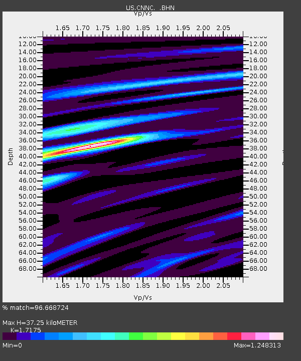
| Estimated Moho Depth: |
37.25 km |
| Estimated Crust Vp/Vs: |
1.72 |
| Assumed Crust Vp: |
6.565 km/s |
| Estimated Crust Vs: |
3.822 km/s |
| Estimated Crust Poisson's Ratio: |
0.24 |
|
| Radial Match: |
96.668724 % |
| Radial Bump: |
400 |
| Transverse Match: |
90.320694 % |
| Transverse Bump: |
400 |
| SOD ConfigId: |
2564 |
| Insert Time: |
2010-03-05 01:08:05.638 +0000 |
| GWidth: |
2.5 |
| Max Bumps: |
400 |
| Tol: |
0.001 |
|
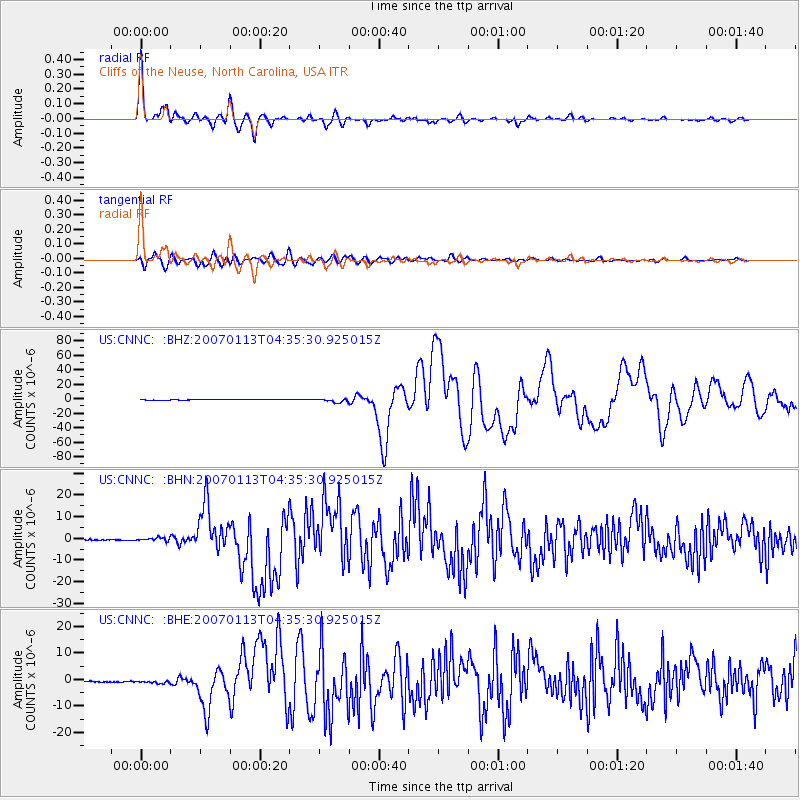
Signal To Noise
| Channel | StoN | STA | LTA |
| US:CNNC: :BHN:20070113T04:35:30.925015Z | 4.6251516 | 7.8633815E-7 | 1.700135E-7 |
| US:CNNC: :BHE:20070113T04:35:30.925015Z | 2.5644472 | 7.1521623E-7 | 2.7889686E-7 |
| US:CNNC: :BHZ:20070113T04:35:30.925015Z | 8.879289 | 2.3457353E-6 | 2.6418056E-7 |
| Arrivals |
| Ps | 4.2 SECOND |
| PpPs | 15 SECOND |
| PsPs/PpSs | 19 SECOND |


