You are here: Home > Network List > JP - Japan Meteorological Agency Seismic Network Stations List
> Station JMM Miyagi Marumori > Earthquake Result Viewer
JMM Miyagi Marumori - Earthquake Result Viewer
| Earthquake location: |
Afghanistan-Tajikistan Bord Reg. |
| Earthquake latitude/longitude: |
36.5/71.2 |
| Earthquake time(UTC): |
2016/04/10 (101) 10:28:58 GMT |
| Earthquake Depth: |
210 km |
| Earthquake Magnitude: |
6.6 MWB |
| Earthquake Catalog/Contributor: |
NEIC PDE/NEIC COMCAT |
|
| Network: |
JP Japan Meteorological Agency Seismic Network |
| Station: |
JMM Miyagi Marumori |
| Lat/Lon: |
37.87 N/140.79 E |
| Elevation: |
100 m |
|
| Distance: |
54.3 deg |
| Az: |
66.053 deg |
| Baz: |
291.473 deg |
| Ray Param: |
0.06482057 |
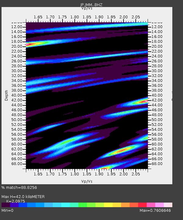
| Estimated Moho Depth: |
42.0 km |
| Estimated Crust Vp/Vs: |
2.10 |
| Assumed Crust Vp: |
6.24 km/s |
| Estimated Crust Vs: |
2.975 km/s |
| Estimated Crust Poisson's Ratio: |
0.35 |
|
| Radial Match: |
88.8256 % |
| Radial Bump: |
400 |
| Transverse Match: |
88.46572 % |
| Transverse Bump: |
400 |
| SOD ConfigId: |
7422571 |
| Insert Time: |
2019-04-22 04:42:27.673 +0000 |
| GWidth: |
2.5 |
| Max Bumps: |
400 |
| Tol: |
0.001 |
|

Signal To Noise
| Channel | StoN | STA | LTA |
| JP:JMM: :BHZ:20160410T10:37:32.299998Z | 29.668642 | 1.1028744E-5 | 3.7173064E-7 |
| JP:JMM: :BHN:20160410T10:37:32.299998Z | 5.3751383 | 2.6094856E-6 | 4.854732E-7 |
| JP:JMM: :BHE:20160410T10:37:32.299998Z | 10.683839 | 3.6868794E-6 | 3.450894E-7 |
| Arrivals |
| Ps | 7.7 SECOND |
| PpPs | 20 SECOND |
| PsPs/PpSs | 28 SECOND |


