You are here: Home > Network List > JP - Japan Meteorological Agency Seismic Network Stations List
> Station JSU Kagoshima Suzuyama > Earthquake Result Viewer
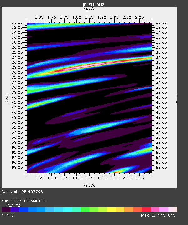
JSU Kagoshima Suzuyama - Earthquake Result Viewer
| Earthquake location: |
Afghanistan-Tajikistan Bord Reg. |
| Earthquake latitude/longitude: |
36.5/71.2 |
| Earthquake time(UTC): |
2016/04/10 (101) 10:28:58 GMT |
| Earthquake Depth: |
210 km |
| Earthquake Magnitude: |
6.6 MWB |
| Earthquake Catalog/Contributor: |
NEIC PDE/NEIC COMCAT |
|
| Network: |
JP Japan Meteorological Agency Seismic Network |
| Station: |
JSU Kagoshima Suzuyama |
| Lat/Lon: |
31.51 N/130.45 E |
| Elevation: |
400 m |
|
| Distance: |
48.7 deg |
| Az: |
77.644 deg |
| Baz: |
292.834 deg |
| Ray Param: |
0.06837055 |
| Estimated Moho Depth: |
27.0 km |
| Estimated Crust Vp/Vs: |
1.84 |
| Assumed Crust Vp: |
6.468 km/s |
| Estimated Crust Vs: |
3.515 km/s |
| Estimated Crust Poisson's Ratio: |
0.29 |
|
| Radial Match: |
95.687706 % |
| Radial Bump: |
335 |
| Transverse Match: |
86.56928 % |
| Transverse Bump: |
400 |
| SOD ConfigId: |
7422571 |
| Insert Time: |
2019-04-22 04:42:31.899 +0000 |
| GWidth: |
2.5 |
| Max Bumps: |
400 |
| Tol: |
0.001 |
|

Signal To Noise
| Channel | StoN | STA | LTA |
| JP:JSU: :BHZ:20160410T10:36:51.449991Z | 81.37003 | 9.588819E-6 | 1.1784214E-7 |
| JP:JSU: :BHN:20160410T10:36:51.449991Z | 14.8951025 | 2.1032918E-6 | 1.4120693E-7 |
| JP:JSU: :BHE:20160410T10:36:51.449991Z | 31.144619 | 3.7515704E-6 | 1.2045646E-7 |
| Arrivals |
| Ps | 3.7 SECOND |
| PpPs | 11 SECOND |
| PsPs/PpSs | 15 SECOND |


