You are here: Home > Network List > KO - Kandilli Observatory Digital Broadband Seismic Network Stations List
> Station MDUB Mudurnu-Bolu-Turkey > Earthquake Result Viewer
MDUB Mudurnu-Bolu-Turkey - Earthquake Result Viewer
| Earthquake location: |
Afghanistan-Tajikistan Bord Reg. |
| Earthquake latitude/longitude: |
36.5/71.2 |
| Earthquake time(UTC): |
2016/04/10 (101) 10:28:58 GMT |
| Earthquake Depth: |
210 km |
| Earthquake Magnitude: |
6.6 MWB |
| Earthquake Catalog/Contributor: |
NEIC PDE/NEIC COMCAT |
|
| Network: |
KO Kandilli Observatory Digital Broadband Seismic Network |
| Station: |
MDUB Mudurnu-Bolu-Turkey |
| Lat/Lon: |
40.47 N/31.20 E |
| Elevation: |
1109 m |
|
| Distance: |
31.3 deg |
| Az: |
289.631 deg |
| Baz: |
84.223 deg |
| Ray Param: |
0.078478344 |
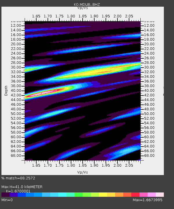
| Estimated Moho Depth: |
41.0 km |
| Estimated Crust Vp/Vs: |
1.67 |
| Assumed Crust Vp: |
6.287 km/s |
| Estimated Crust Vs: |
3.765 km/s |
| Estimated Crust Poisson's Ratio: |
0.22 |
|
| Radial Match: |
88.2572 % |
| Radial Bump: |
400 |
| Transverse Match: |
84.63367 % |
| Transverse Bump: |
400 |
| SOD ConfigId: |
7422571 |
| Insert Time: |
2019-04-22 04:42:36.671 +0000 |
| GWidth: |
2.5 |
| Max Bumps: |
400 |
| Tol: |
0.001 |
|

Signal To Noise
| Channel | StoN | STA | LTA |
| KO:MDUB: :BHZ:20160410T10:34:28.780009Z | 75.092384 | 2.3400264E-5 | 3.1161966E-7 |
| KO:MDUB: :BHN:20160410T10:34:28.780009Z | 8.558409 | 2.556663E-6 | 2.987311E-7 |
| KO:MDUB: :BHE:20160410T10:34:28.780009Z | 27.473948 | 1.2481593E-5 | 4.5430653E-7 |
| Arrivals |
| Ps | 4.7 SECOND |
| PpPs | 16 SECOND |
| PsPs/PpSs | 21 SECOND |


