You are here: Home > Network List > MB - Montana Regional Seismic Network Stations List
> Station JTMT Jette Lake, Montana > Earthquake Result Viewer
JTMT Jette Lake, Montana - Earthquake Result Viewer
| Earthquake location: |
Afghanistan-Tajikistan Bord Reg. |
| Earthquake latitude/longitude: |
36.5/71.2 |
| Earthquake time(UTC): |
2016/04/10 (101) 10:28:58 GMT |
| Earthquake Depth: |
210 km |
| Earthquake Magnitude: |
6.6 MWB |
| Earthquake Catalog/Contributor: |
NEIC PDE/NEIC COMCAT |
|
| Network: |
MB Montana Regional Seismic Network |
| Station: |
JTMT Jette Lake, Montana |
| Lat/Lon: |
47.75 N/114.28 W |
| Elevation: |
1469 m |
|
| Distance: |
96.0 deg |
| Az: |
3.688 deg |
| Baz: |
355.595 deg |
| Ray Param: |
0.04045912 |
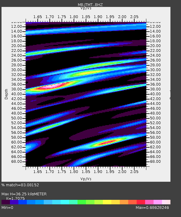
| Estimated Moho Depth: |
36.25 km |
| Estimated Crust Vp/Vs: |
1.71 |
| Assumed Crust Vp: |
6.622 km/s |
| Estimated Crust Vs: |
3.878 km/s |
| Estimated Crust Poisson's Ratio: |
0.24 |
|
| Radial Match: |
83.08152 % |
| Radial Bump: |
400 |
| Transverse Match: |
73.191154 % |
| Transverse Bump: |
400 |
| SOD ConfigId: |
7422571 |
| Insert Time: |
2019-04-22 04:43:02.205 +0000 |
| GWidth: |
2.5 |
| Max Bumps: |
400 |
| Tol: |
0.001 |
|

Signal To Noise
| Channel | StoN | STA | LTA |
| MB:JTMT: :BHZ:20160410T10:41:30.169993Z | 22.602997 | 2.7371075E-6 | 1.2109489E-7 |
| MB:JTMT: :BHN:20160410T10:41:30.169993Z | 5.6705613 | 9.1457844E-7 | 1.6128534E-7 |
| MB:JTMT: :BHE:20160410T10:41:30.169993Z | 2.7684336 | 4.0253258E-7 | 1.4540085E-7 |
| Arrivals |
| Ps | 4.0 SECOND |
| PpPs | 15 SECOND |
| PsPs/PpSs | 18 SECOND |


