You are here: Home > Network List > US - United States National Seismic Network Stations List
> Station CNNC Cliffs of the Neuse, North Carolina, USA > Earthquake Result Viewer
CNNC Cliffs of the Neuse, North Carolina, USA - Earthquake Result Viewer
| Earthquake location: |
Near Coast Of Peru |
| Earthquake latitude/longitude: |
-13.5/-76.7 |
| Earthquake time(UTC): |
2006/10/20 (293) 10:48:56 GMT |
| Earthquake Depth: |
23 km |
| Earthquake Magnitude: |
5.9 MB, 6.6 MS, 6.7 MW, 6.6 MW |
| Earthquake Catalog/Contributor: |
WHDF/NEIC |
|
| Network: |
US United States National Seismic Network |
| Station: |
CNNC Cliffs of the Neuse, North Carolina, USA |
| Lat/Lon: |
35.24 N/77.88 W |
| Elevation: |
17 m |
|
| Distance: |
48.4 deg |
| Az: |
358.684 deg |
| Baz: |
178.436 deg |
| Ray Param: |
0.069323614 |
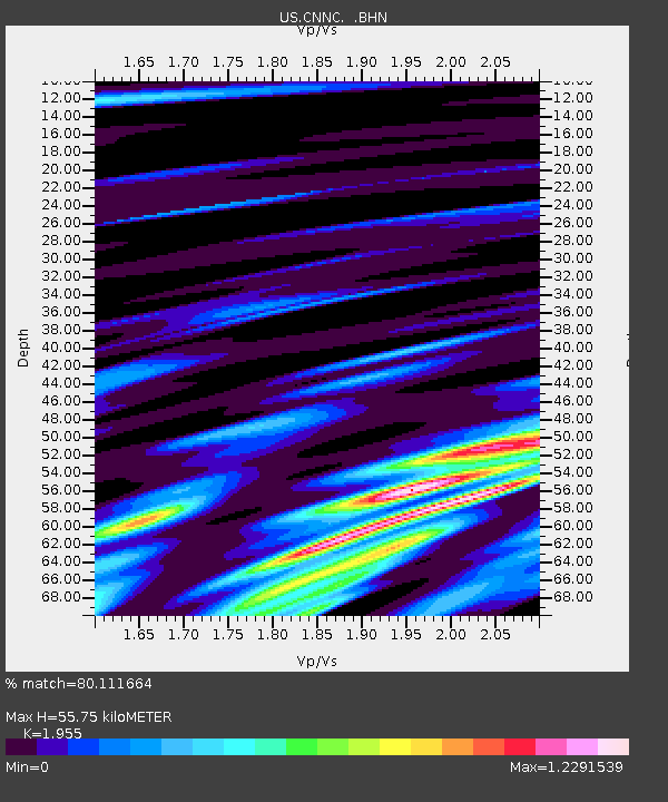
| Estimated Moho Depth: |
55.75 km |
| Estimated Crust Vp/Vs: |
1.96 |
| Assumed Crust Vp: |
6.565 km/s |
| Estimated Crust Vs: |
3.358 km/s |
| Estimated Crust Poisson's Ratio: |
0.32 |
|
| Radial Match: |
80.111664 % |
| Radial Bump: |
400 |
| Transverse Match: |
41.071274 % |
| Transverse Bump: |
400 |
| SOD ConfigId: |
2564 |
| Insert Time: |
2010-03-05 01:08:36.505 +0000 |
| GWidth: |
2.5 |
| Max Bumps: |
400 |
| Tol: |
0.001 |
|
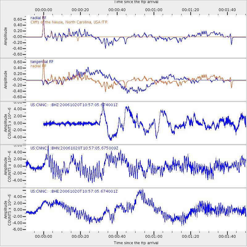
Signal To Noise
| Channel | StoN | STA | LTA |
| US:CNNC: :BHN:20061020T10:57:05.675009Z | 3.914566 | 2.5954046E-6 | 6.6301203E-7 |
| US:CNNC: :BHE:20061020T10:57:05.674001Z | 6.61755 | 3.5533549E-6 | 5.369593E-7 |
| US:CNNC: :BHZ:20061020T10:57:05.674001Z | 8.012256 | 2.4659212E-6 | 3.0776866E-7 |
| Arrivals |
| Ps | 8.6 SECOND |
| PpPs | 24 SECOND |
| PsPs/PpSs | 32 SECOND |


