You are here: Home > Network List > CI - Caltech Regional Seismic Network Stations List
> Station BAR Barrett, Tecate, CA, USA > Earthquake Result Viewer
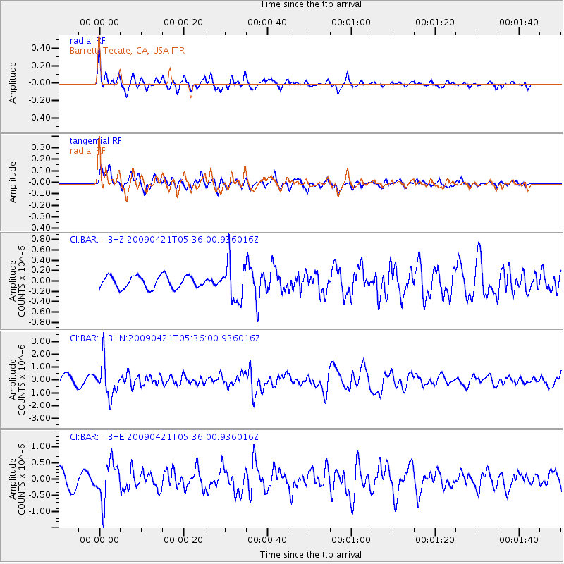
BAR Barrett, Tecate, CA, USA - Earthquake Result Viewer
*The percent match for this event was below the threshold and hence no stack was calculated.
| Earthquake location: |
Kuril Islands |
| Earthquake latitude/longitude: |
50.8/155.0 |
| Earthquake time(UTC): |
2009/04/21 (111) 05:26:11 GMT |
| Earthquake Depth: |
152 km |
| Earthquake Magnitude: |
6.0 MB, 6.2 MW, 6.2 MW |
| Earthquake Catalog/Contributor: |
WHDF/NEIC |
|
| Network: |
CI Caltech Regional Seismic Network |
| Station: |
BAR Barrett, Tecate, CA, USA |
| Lat/Lon: |
32.68 N/116.67 W |
| Elevation: |
521 m |
|
| Distance: |
64.5 deg |
| Az: |
69.116 deg |
| Baz: |
315.37 deg |
| Ray Param: |
$rayparam |
*The percent match for this event was below the threshold and hence was not used in the summary stack. |
|
| Radial Match: |
78.16305 % |
| Radial Bump: |
400 |
| Transverse Match: |
76.02056 % |
| Transverse Bump: |
400 |
| SOD ConfigId: |
2760 |
| Insert Time: |
2010-02-26 00:13:07.543 +0000 |
| GWidth: |
2.5 |
| Max Bumps: |
400 |
| Tol: |
0.001 |
|
Signal To Noise
| Channel | StoN | STA | LTA |
| CI:BAR: :BHN:20090421T05:36:00.936016Z | 3.2448196 | 1.3489881E-6 | 4.1573594E-7 |
| CI:BAR: :BHE:20090421T05:36:00.936016Z | 2.0699825 | 6.016602E-7 | 2.9065956E-7 |
| CI:BAR: :BHZ:20090421T05:36:00.936016Z | 3.253047 | 3.7765662E-7 | 1.1609319E-7 |
| Arrivals |
| Ps | |
| PpPs | |
| PsPs/PpSs | |


