You are here: Home > Network List > S - Seismographs in Schools Projects Stations List
> Station AUNHS Nhulunbuy High School, NT > Earthquake Result Viewer
AUNHS Nhulunbuy High School, NT - Earthquake Result Viewer
| Earthquake location: |
Afghanistan-Tajikistan Bord Reg. |
| Earthquake latitude/longitude: |
36.5/71.2 |
| Earthquake time(UTC): |
2016/04/10 (101) 10:28:58 GMT |
| Earthquake Depth: |
210 km |
| Earthquake Magnitude: |
6.6 MWB |
| Earthquake Catalog/Contributor: |
NEIC PDE/NEIC COMCAT |
|
| Network: |
S Seismographs in Schools Projects |
| Station: |
AUNHS Nhulunbuy High School, NT |
| Lat/Lon: |
12.19 S/136.78 E |
| Elevation: |
20 m |
|
| Distance: |
78.4 deg |
| Az: |
114.611 deg |
| Baz: |
311.469 deg |
| Ray Param: |
0.049126804 |
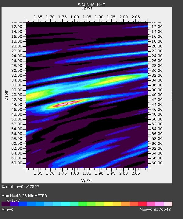
| Estimated Moho Depth: |
43.25 km |
| Estimated Crust Vp/Vs: |
1.77 |
| Assumed Crust Vp: |
6.472 km/s |
| Estimated Crust Vs: |
3.656 km/s |
| Estimated Crust Poisson's Ratio: |
0.27 |
|
| Radial Match: |
94.07527 % |
| Radial Bump: |
364 |
| Transverse Match: |
78.19767 % |
| Transverse Bump: |
400 |
| SOD ConfigId: |
7422571 |
| Insert Time: |
2019-04-22 04:44:45.530 +0000 |
| GWidth: |
2.5 |
| Max Bumps: |
400 |
| Tol: |
0.001 |
|

Signal To Noise
| Channel | StoN | STA | LTA |
| S:AUNHS: :HHZ:20160410T10:40:04.680002Z | 30.908989 | 1.3019712E-5 | 4.2122736E-7 |
| S:AUNHS: :HHN:20160410T10:40:04.680002Z | 16.726765 | 4.3028617E-6 | 2.5724412E-7 |
| S:AUNHS: :HHE:20160410T10:40:04.680002Z | 17.029385 | 6.401814E-6 | 3.759275E-7 |
| Arrivals |
| Ps | 5.3 SECOND |
| PpPs | 18 SECOND |
| PsPs/PpSs | 23 SECOND |


