You are here: Home > Network List > TA - USArray Transportable Network (new EarthScope stations) Stations List
> Station G03D McMinnville, OR, USA > Earthquake Result Viewer
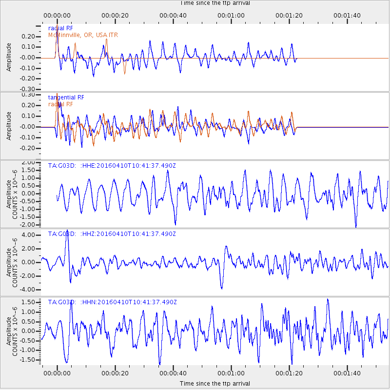
G03D McMinnville, OR, USA - Earthquake Result Viewer
*The percent match for this event was below the threshold and hence no stack was calculated.
| Earthquake location: |
Afghanistan-Tajikistan Bord Reg. |
| Earthquake latitude/longitude: |
36.5/71.2 |
| Earthquake time(UTC): |
2016/04/10 (101) 10:28:58 GMT |
| Earthquake Depth: |
210 km |
| Earthquake Magnitude: |
6.6 MWB |
| Earthquake Catalog/Contributor: |
NEIC PDE/NEIC COMCAT |
|
| Network: |
TA USArray Transportable Network (new EarthScope stations) |
| Station: |
G03D McMinnville, OR, USA |
| Lat/Lon: |
45.21 N/123.26 W |
| Elevation: |
222 m |
|
| Distance: |
97.6 deg |
| Az: |
10.231 deg |
| Baz: |
348.318 deg |
| Ray Param: |
$rayparam |
*The percent match for this event was below the threshold and hence was not used in the summary stack. |
|
| Radial Match: |
71.078224 % |
| Radial Bump: |
400 |
| Transverse Match: |
69.896736 % |
| Transverse Bump: |
308 |
| SOD ConfigId: |
7422571 |
| Insert Time: |
2019-04-22 04:45:10.136 +0000 |
| GWidth: |
2.5 |
| Max Bumps: |
400 |
| Tol: |
0.001 |
|
Signal To Noise
| Channel | StoN | STA | LTA |
| TA:G03D: :HHZ:20160410T10:41:37.490Z | 2.9371583 | 2.0340167E-6 | 6.925118E-7 |
| TA:G03D: :HHN:20160410T10:41:37.490Z | 2.8284154 | 8.9837056E-7 | 3.176233E-7 |
| TA:G03D: :HHE:20160410T10:41:37.490Z | 1.2167122 | 7.427771E-7 | 6.104789E-7 |
| Arrivals |
| Ps | |
| PpPs | |
| PsPs/PpSs | |


