You are here: Home > Network List > TA - USArray Transportable Network (new EarthScope stations) Stations List
> Station H21K Melozitna River, AK, USA > Earthquake Result Viewer
H21K Melozitna River, AK, USA - Earthquake Result Viewer
| Earthquake location: |
Afghanistan-Tajikistan Bord Reg. |
| Earthquake latitude/longitude: |
36.5/71.2 |
| Earthquake time(UTC): |
2016/04/10 (101) 10:28:58 GMT |
| Earthquake Depth: |
210 km |
| Earthquake Magnitude: |
6.6 MWB |
| Earthquake Catalog/Contributor: |
NEIC PDE/NEIC COMCAT |
|
| Network: |
TA USArray Transportable Network (new EarthScope stations) |
| Station: |
H21K Melozitna River, AK, USA |
| Lat/Lon: |
65.66 N/152.80 W |
| Elevation: |
520 m |
|
| Distance: |
72.6 deg |
| Az: |
17.546 deg |
| Baz: |
324.119 deg |
| Ray Param: |
0.052962884 |
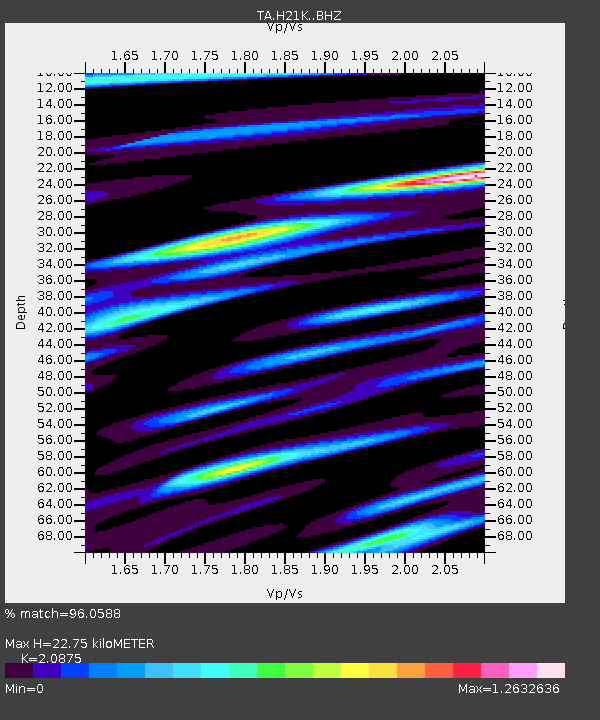
| Estimated Moho Depth: |
22.75 km |
| Estimated Crust Vp/Vs: |
2.09 |
| Assumed Crust Vp: |
6.566 km/s |
| Estimated Crust Vs: |
3.145 km/s |
| Estimated Crust Poisson's Ratio: |
0.35 |
|
| Radial Match: |
96.0588 % |
| Radial Bump: |
325 |
| Transverse Match: |
86.93274 % |
| Transverse Bump: |
400 |
| SOD ConfigId: |
7422571 |
| Insert Time: |
2019-04-22 04:45:12.306 +0000 |
| GWidth: |
2.5 |
| Max Bumps: |
400 |
| Tol: |
0.001 |
|

Signal To Noise
| Channel | StoN | STA | LTA |
| TA:H21K: :BHZ:20160410T10:39:32.12501Z | 66.41254 | 9.463414E-6 | 1.424944E-7 |
| TA:H21K: :BHN:20160410T10:39:32.12501Z | 22.306257 | 3.1334919E-6 | 1.4047592E-7 |
| TA:H21K: :BHE:20160410T10:39:32.12501Z | 25.732351 | 2.9067044E-6 | 1.1295914E-7 |
| Arrivals |
| Ps | 3.9 SECOND |
| PpPs | 10 SECOND |
| PsPs/PpSs | 14 SECOND |


