You are here: Home > Network List > TA - USArray Transportable Network (new EarthScope stations) Stations List
> Station M31M Drury Creek, Yukon, CA > Earthquake Result Viewer
M31M Drury Creek, Yukon, CA - Earthquake Result Viewer

| Earthquake location: |
Afghanistan-Tajikistan Bord Reg. |
| Earthquake latitude/longitude: |
36.5/71.2 |
| Earthquake time(UTC): |
2016/04/10 (101) 10:28:58 GMT |
| Earthquake Depth: |
210 km |
| Earthquake Magnitude: |
6.6 MWB |
| Earthquake Catalog/Contributor: |
NEIC PDE/NEIC COMCAT |
|
| Network: |
TA USArray Transportable Network (new EarthScope stations) |
| Station: |
M31M Drury Creek, Yukon, CA |
| Lat/Lon: |
62.20 N/134.39 W |
| Elevation: |
639 m |
|
| Distance: |
79.5 deg |
| Az: |
11.865 deg |
| Baz: |
339.302 deg |
| Ray Param: |
0.04838612 |
| Estimated Moho Depth: |
36.75 km |
| Estimated Crust Vp/Vs: |
1.64 |
| Assumed Crust Vp: |
6.419 km/s |
| Estimated Crust Vs: |
3.902 km/s |
| Estimated Crust Poisson's Ratio: |
0.21 |
|
| Radial Match: |
87.6597 % |
| Radial Bump: |
400 |
| Transverse Match: |
82.4029 % |
| Transverse Bump: |
400 |
| SOD ConfigId: |
7422571 |
| Insert Time: |
2019-04-22 04:45:30.045 +0000 |
| GWidth: |
2.5 |
| Max Bumps: |
400 |
| Tol: |
0.001 |
|
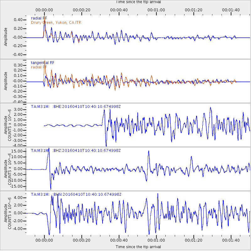
Signal To Noise
| Channel | StoN | STA | LTA |
| TA:M31M: :BHZ:20160410T10:40:10.674998Z | 48.763958 | 8.47435E-6 | 1.7378306E-7 |
| TA:M31M: :BHN:20160410T10:40:10.674998Z | 30.637701 | 2.727839E-6 | 8.903537E-8 |
| TA:M31M: :BHE:20160410T10:40:10.674998Z | 14.850201 | 1.6633395E-6 | 1.1200788E-7 |
| Arrivals |
| Ps | 3.8 SECOND |
| PpPs | 15 SECOND |
| PsPs/PpSs | 18 SECOND |


