You are here: Home > Network List > TA - USArray Transportable Network (new EarthScope stations) Stations List
> Station MDND Maddock, ND, USA > Earthquake Result Viewer
MDND Maddock, ND, USA - Earthquake Result Viewer
*The percent match for this event was below the threshold and hence no stack was calculated.
| Earthquake location: |
Afghanistan-Tajikistan Bord Reg. |
| Earthquake latitude/longitude: |
36.5/71.2 |
| Earthquake time(UTC): |
2016/04/10 (101) 10:28:58 GMT |
| Earthquake Depth: |
210 km |
| Earthquake Magnitude: |
6.6 MWB |
| Earthquake Catalog/Contributor: |
NEIC PDE/NEIC COMCAT |
|
| Network: |
TA USArray Transportable Network (new EarthScope stations) |
| Station: |
MDND Maddock, ND, USA |
| Lat/Lon: |
47.85 N/99.60 W |
| Elevation: |
479 m |
|
| Distance: |
95.6 deg |
| Az: |
353.76 deg |
| Baz: |
7.471 deg |
| Ray Param: |
$rayparam |
*The percent match for this event was below the threshold and hence was not used in the summary stack. |
|
| Radial Match: |
69.31794 % |
| Radial Bump: |
326 |
| Transverse Match: |
41.664165 % |
| Transverse Bump: |
352 |
| SOD ConfigId: |
7422571 |
| Insert Time: |
2019-04-22 04:45:30.773 +0000 |
| GWidth: |
2.5 |
| Max Bumps: |
400 |
| Tol: |
0.001 |
|
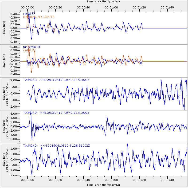
Signal To Noise
| Channel | StoN | STA | LTA |
| TA:MDND: :HHZ:20160410T10:41:28.51002Z | 20.127573 | 3.1049117E-6 | 1.542616E-7 |
| TA:MDND: :HHN:20160410T10:41:28.51002Z | 1.5132781 | 1.1618959E-6 | 7.6780054E-7 |
| TA:MDND: :HHE:20160410T10:41:28.51002Z | 1.4000653 | 7.203827E-7 | 5.145351E-7 |
| Arrivals |
| Ps | |
| PpPs | |
| PsPs/PpSs | |


