You are here: Home > Network List > TM - Thai Seismic Monitoring Network Stations List
> Station LOEI LOEI staion > Earthquake Result Viewer
LOEI LOEI staion - Earthquake Result Viewer
| Earthquake location: |
Afghanistan-Tajikistan Bord Reg. |
| Earthquake latitude/longitude: |
36.5/71.2 |
| Earthquake time(UTC): |
2016/04/10 (101) 10:28:58 GMT |
| Earthquake Depth: |
210 km |
| Earthquake Magnitude: |
6.6 MWB |
| Earthquake Catalog/Contributor: |
NEIC PDE/NEIC COMCAT |
|
| Network: |
TM Thai Seismic Monitoring Network |
| Station: |
LOEI LOEI staion |
| Lat/Lon: |
17.51 N/101.62 E |
| Elevation: |
305 m |
|
| Distance: |
32.9 deg |
| Az: |
116.953 deg |
| Baz: |
311.171 deg |
| Ray Param: |
0.07778469 |
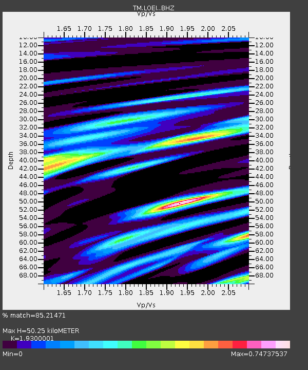
| Estimated Moho Depth: |
50.25 km |
| Estimated Crust Vp/Vs: |
1.93 |
| Assumed Crust Vp: |
6.35 km/s |
| Estimated Crust Vs: |
3.29 km/s |
| Estimated Crust Poisson's Ratio: |
0.32 |
|
| Radial Match: |
85.21471 % |
| Radial Bump: |
371 |
| Transverse Match: |
84.08565 % |
| Transverse Bump: |
400 |
| SOD ConfigId: |
7422571 |
| Insert Time: |
2019-04-22 04:45:45.654 +0000 |
| GWidth: |
2.5 |
| Max Bumps: |
400 |
| Tol: |
0.001 |
|

Signal To Noise
| Channel | StoN | STA | LTA |
| TM:LOEI: :BHZ:20160410T10:34:42.259989Z | 21.040585 | 1.1088335E-5 | 5.2699744E-7 |
| TM:LOEI: :BHN:20160410T10:34:42.259989Z | 1.7217345 | 7.0668193E-7 | 4.1044768E-7 |
| TM:LOEI: :BHE:20160410T10:34:42.259989Z | 27.093237 | 4.189139E-6 | 1.5461937E-7 |
| Arrivals |
| Ps | 7.9 SECOND |
| PpPs | 22 SECOND |
| PsPs/PpSs | 30 SECOND |


