You are here: Home > Network List > UW - Pacific Northwest Regional Seismic Network Stations List
> Station LEBA Lebam, WA, USA > Earthquake Result Viewer
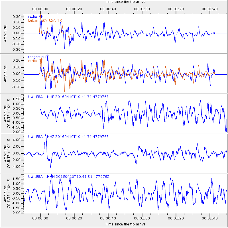
LEBA Lebam, WA, USA - Earthquake Result Viewer
*The percent match for this event was below the threshold and hence no stack was calculated.
| Earthquake location: |
Afghanistan-Tajikistan Bord Reg. |
| Earthquake latitude/longitude: |
36.5/71.2 |
| Earthquake time(UTC): |
2016/04/10 (101) 10:28:58 GMT |
| Earthquake Depth: |
210 km |
| Earthquake Magnitude: |
6.6 MWB |
| Earthquake Catalog/Contributor: |
NEIC PDE/NEIC COMCAT |
|
| Network: |
UW Pacific Northwest Regional Seismic Network |
| Station: |
LEBA Lebam, WA, USA |
| Lat/Lon: |
46.55 N/123.56 W |
| Elevation: |
73 m |
|
| Distance: |
96.3 deg |
| Az: |
10.162 deg |
| Baz: |
348.112 deg |
| Ray Param: |
$rayparam |
*The percent match for this event was below the threshold and hence was not used in the summary stack. |
|
| Radial Match: |
75.768234 % |
| Radial Bump: |
400 |
| Transverse Match: |
63.43034 % |
| Transverse Bump: |
400 |
| SOD ConfigId: |
7422571 |
| Insert Time: |
2019-04-22 04:46:06.708 +0000 |
| GWidth: |
2.5 |
| Max Bumps: |
400 |
| Tol: |
0.001 |
|
Signal To Noise
| Channel | StoN | STA | LTA |
| UW:LEBA: :HHZ:20160410T10:41:31.477976Z | 10.545446 | 2.272877E-6 | 2.155316E-7 |
| UW:LEBA: :HHN:20160410T10:41:31.477976Z | 2.1741893 | 7.135233E-7 | 3.2817903E-7 |
| UW:LEBA: :HHE:20160410T10:41:31.477976Z | 0.45485246 | 1.628674E-7 | 3.5806644E-7 |
| Arrivals |
| Ps | |
| PpPs | |
| PsPs/PpSs | |


