You are here: Home > Network List > XD14 - Illuminating the architecture of the greater Mount St. Helens magmatic systems f Stations List
> Station MD12 "Mount St Helens, WA" > Earthquake Result Viewer
MD12 "Mount St Helens, WA" - Earthquake Result Viewer
| Earthquake location: |
Afghanistan-Tajikistan Bord Reg. |
| Earthquake latitude/longitude: |
36.5/71.2 |
| Earthquake time(UTC): |
2016/04/10 (101) 10:28:58 GMT |
| Earthquake Depth: |
210 km |
| Earthquake Magnitude: |
6.6 MWB |
| Earthquake Catalog/Contributor: |
NEIC PDE/NEIC COMCAT |
|
| Network: |
XD Illuminating the architecture of the greater Mount St. Helens magmatic systems f |
| Station: |
MD12 "Mount St Helens, WA" |
| Lat/Lon: |
46.48 N/121.22 W |
| Elevation: |
1496 m |
|
| Distance: |
96.7 deg |
| Az: |
8.577 deg |
| Baz: |
349.985 deg |
| Ray Param: |
0.040259853 |
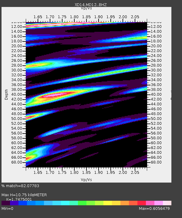
| Estimated Moho Depth: |
10.75 km |
| Estimated Crust Vp/Vs: |
1.75 |
| Assumed Crust Vp: |
6.597 km/s |
| Estimated Crust Vs: |
3.775 km/s |
| Estimated Crust Poisson's Ratio: |
0.26 |
|
| Radial Match: |
82.07783 % |
| Radial Bump: |
400 |
| Transverse Match: |
64.002785 % |
| Transverse Bump: |
391 |
| SOD ConfigId: |
7422571 |
| Insert Time: |
2019-04-22 04:46:41.944 +0000 |
| GWidth: |
2.5 |
| Max Bumps: |
400 |
| Tol: |
0.001 |
|

Signal To Noise
| Channel | StoN | STA | LTA |
| XD:MD12: :BHZ:20160410T10:41:33.154978Z | 11.304776 | 2.2656968E-6 | 2.0041944E-7 |
| XD:MD12: :BHN:20160410T10:41:33.154978Z | 5.144287 | 5.623255E-7 | 1.09310676E-7 |
| XD:MD12: :BHE:20160410T10:41:33.154978Z | 1.1862739 | 2.5636746E-7 | 2.1611152E-7 |
| Arrivals |
| Ps | 1.2 SECOND |
| PpPs | 4.4 SECOND |
| PsPs/PpSs | 5.6 SECOND |


