You are here: Home > Network List > XD14 - Illuminating the architecture of the greater Mount St. Helens magmatic systems f Stations List
> Station MI08 "Mount St Helens, WA" > Earthquake Result Viewer
MI08 "Mount St Helens, WA" - Earthquake Result Viewer
| Earthquake location: |
Afghanistan-Tajikistan Bord Reg. |
| Earthquake latitude/longitude: |
36.5/71.2 |
| Earthquake time(UTC): |
2016/04/10 (101) 10:28:58 GMT |
| Earthquake Depth: |
210 km |
| Earthquake Magnitude: |
6.6 MWB |
| Earthquake Catalog/Contributor: |
NEIC PDE/NEIC COMCAT |
|
| Network: |
XD Illuminating the architecture of the greater Mount St. Helens magmatic systems f |
| Station: |
MI08 "Mount St Helens, WA" |
| Lat/Lon: |
46.25 N/121.97 W |
| Elevation: |
1246 m |
|
| Distance: |
96.8 deg |
| Az: |
9.134 deg |
| Baz: |
349.376 deg |
| Ray Param: |
0.040222038 |
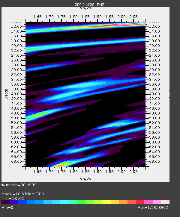
| Estimated Moho Depth: |
10.5 km |
| Estimated Crust Vp/Vs: |
2.10 |
| Assumed Crust Vp: |
6.597 km/s |
| Estimated Crust Vs: |
3.145 km/s |
| Estimated Crust Poisson's Ratio: |
0.35 |
|
| Radial Match: |
80.6909 % |
| Radial Bump: |
400 |
| Transverse Match: |
61.112473 % |
| Transverse Bump: |
400 |
| SOD ConfigId: |
7422571 |
| Insert Time: |
2019-04-22 04:46:56.567 +0000 |
| GWidth: |
2.5 |
| Max Bumps: |
400 |
| Tol: |
0.001 |
|

Signal To Noise
| Channel | StoN | STA | LTA |
| XD:MI08: :BHZ:20160410T10:41:33.71998Z | 12.804171 | 2.0507528E-6 | 1.6016288E-7 |
| XD:MI08: :BHN:20160410T10:41:33.71998Z | 5.6914945 | 6.842394E-7 | 1.2022139E-7 |
| XD:MI08: :BHE:20160410T10:41:33.71998Z | 1.7340816 | 2.3864507E-7 | 1.3762043E-7 |
| Arrivals |
| Ps | 1.8 SECOND |
| PpPs | 4.8 SECOND |
| PsPs/PpSs | 6.6 SECOND |


