You are here: Home > Network List > XD14 - Illuminating the architecture of the greater Mount St. Helens magmatic systems f Stations List
> Station MM04 "Mount St Helens, WA" > Earthquake Result Viewer
MM04 "Mount St Helens, WA" - Earthquake Result Viewer
| Earthquake location: |
Afghanistan-Tajikistan Bord Reg. |
| Earthquake latitude/longitude: |
36.5/71.2 |
| Earthquake time(UTC): |
2016/04/10 (101) 10:28:58 GMT |
| Earthquake Depth: |
210 km |
| Earthquake Magnitude: |
6.6 MWB |
| Earthquake Catalog/Contributor: |
NEIC PDE/NEIC COMCAT |
|
| Network: |
XD Illuminating the architecture of the greater Mount St. Helens magmatic systems f |
| Station: |
MM04 "Mount St Helens, WA" |
| Lat/Lon: |
46.02 N/122.35 W |
| Elevation: |
313 m |
|
| Distance: |
97.0 deg |
| Az: |
9.434 deg |
| Baz: |
349.074 deg |
| Ray Param: |
0.04016617 |
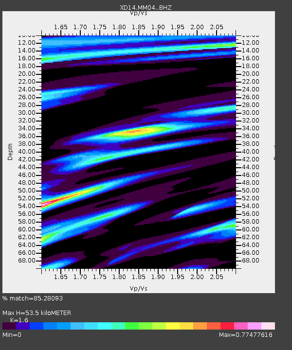
| Estimated Moho Depth: |
53.5 km |
| Estimated Crust Vp/Vs: |
1.60 |
| Assumed Crust Vp: |
6.566 km/s |
| Estimated Crust Vs: |
4.104 km/s |
| Estimated Crust Poisson's Ratio: |
0.18 |
|
| Radial Match: |
85.28093 % |
| Radial Bump: |
397 |
| Transverse Match: |
66.59178 % |
| Transverse Bump: |
400 |
| SOD ConfigId: |
7422571 |
| Insert Time: |
2019-04-22 04:47:12.033 +0000 |
| GWidth: |
2.5 |
| Max Bumps: |
400 |
| Tol: |
0.001 |
|

Signal To Noise
| Channel | StoN | STA | LTA |
| XD:MM04: :BHZ:20160410T10:41:34.544993Z | 14.744689 | 2.093002E-6 | 1.4194956E-7 |
| XD:MM04: :BHN:20160410T10:41:34.544993Z | 3.4929905 | 6.296569E-7 | 1.8026299E-7 |
| XD:MM04: :BHE:20160410T10:41:34.544993Z | 1.4021531 | 2.4425378E-7 | 1.7419909E-7 |
| Arrivals |
| Ps | 5.0 SECOND |
| PpPs | 21 SECOND |
| PsPs/PpSs | 26 SECOND |


