You are here: Home > Network List > WI - West Indies IPGP Network Stations List
> Station TDBA Terre de Bas, Les Saintes > Earthquake Result Viewer
TDBA Terre de Bas, Les Saintes - Earthquake Result Viewer
| Earthquake location: |
Fox Islands, Aleutian Islands |
| Earthquake latitude/longitude: |
52.4/-169.7 |
| Earthquake time(UTC): |
2015/07/27 (208) 04:49:44 GMT |
| Earthquake Depth: |
12 km |
| Earthquake Magnitude: |
6.9 MO |
| Earthquake Catalog/Contributor: |
NEIC PDE/NEIC ALERT |
|
| Network: |
WI West Indies IPGP Network |
| Station: |
TDBA Terre de Bas, Les Saintes |
| Lat/Lon: |
15.85 N/61.64 W |
| Elevation: |
176 m |
|
| Distance: |
88.2 deg |
| Az: |
66.303 deg |
| Baz: |
324.319 deg |
| Ray Param: |
0.042783566 |
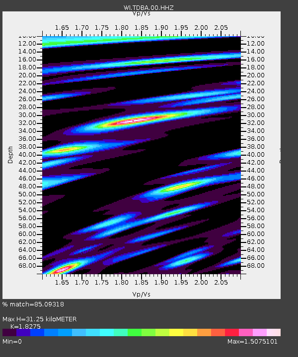
| Estimated Moho Depth: |
31.25 km |
| Estimated Crust Vp/Vs: |
1.83 |
| Assumed Crust Vp: |
5.88 km/s |
| Estimated Crust Vs: |
3.218 km/s |
| Estimated Crust Poisson's Ratio: |
0.29 |
|
| Radial Match: |
85.09318 % |
| Radial Bump: |
400 |
| Transverse Match: |
72.622894 % |
| Transverse Bump: |
400 |
| SOD ConfigId: |
1085051 |
| Insert Time: |
2015-08-10 05:23:49.507 +0000 |
| GWidth: |
2.5 |
| Max Bumps: |
400 |
| Tol: |
0.001 |
|

Signal To Noise
| Channel | StoN | STA | LTA |
| WI:TDBA:00:HHZ:20150727T05:02:03.230005Z | 3.9942057 | 2.1778296E-6 | 5.4524725E-7 |
| WI:TDBA:00:HHN:20150727T05:02:03.230005Z | 1.2767466 | 1.1583933E-6 | 9.0730083E-7 |
| WI:TDBA:00:HHE:20150727T05:02:03.230005Z | 1.140911 | 8.0693167E-7 | 7.0726963E-7 |
| Arrivals |
| Ps | 4.5 SECOND |
| PpPs | 15 SECOND |
| PsPs/PpSs | 19 SECOND |


