You are here: Home > Network List > US - United States National Seismic Network Stations List
> Station ERPA Erie, Pennsylvania, USA > Earthquake Result Viewer
ERPA Erie, Pennsylvania, USA - Earthquake Result Viewer

| Earthquake location: |
Costa Rica |
| Earthquake latitude/longitude: |
9.6/-84.2 |
| Earthquake time(UTC): |
2004/11/20 (325) 08:07:22 GMT |
| Earthquake Depth: |
16 km |
| Earthquake Magnitude: |
6.2 MB, 6.3 MS, 6.4 MW, 6.4 MW |
| Earthquake Catalog/Contributor: |
WHDF/NEIC |
|
| Network: |
US United States National Seismic Network |
| Station: |
ERPA Erie, Pennsylvania, USA |
| Lat/Lon: |
42.12 N/79.99 W |
| Elevation: |
306 m |
|
| Distance: |
32.6 deg |
| Az: |
5.782 deg |
| Baz: |
187.673 deg |
| Ray Param: |
0.078572884 |
| Estimated Moho Depth: |
55.75 km |
| Estimated Crust Vp/Vs: |
1.72 |
| Assumed Crust Vp: |
6.419 km/s |
| Estimated Crust Vs: |
3.743 km/s |
| Estimated Crust Poisson's Ratio: |
0.24 |
|
| Radial Match: |
91.64252 % |
| Radial Bump: |
199 |
| Transverse Match: |
67.39358 % |
| Transverse Bump: |
400 |
| SOD ConfigId: |
110177 |
| Insert Time: |
2010-03-05 01:10:24.566 +0000 |
| GWidth: |
2.5 |
| Max Bumps: |
400 |
| Tol: |
0.001 |
|
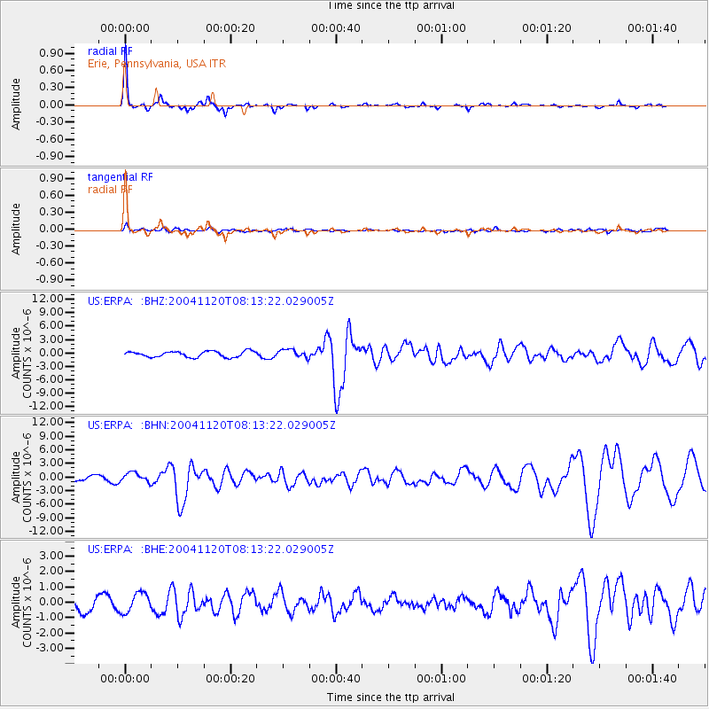
Signal To Noise
| Channel | StoN | STA | LTA |
| US:ERPA: :BHN:20041120T08:13:22.029005Z | 1.4384121 | 1.0227667E-6 | 7.1103875E-7 |
| US:ERPA: :BHE:20041120T08:13:22.029005Z | 1.1291902 | 6.311622E-7 | 5.5895117E-7 |
| US:ERPA: :BHZ:20041120T08:13:22.029005Z | 1.4109148 | 9.215917E-7 | 6.531874E-7 |
| Arrivals |
| Ps | 6.7 SECOND |
| PpPs | 22 SECOND |
| PsPs/PpSs | 28 SECOND |


