You are here: Home > Network List > TA - USArray Transportable Network (new EarthScope stations) Stations List
> Station A36M Sachs Harbour, NT, CAN > Earthquake Result Viewer
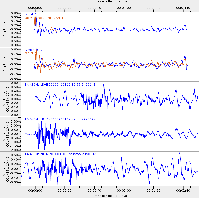
A36M Sachs Harbour, NT, CAN - Earthquake Result Viewer
*The percent match for this event was below the threshold and hence no stack was calculated.
| Earthquake location: |
Rat Islands, Aleutian Islands |
| Earthquake latitude/longitude: |
51.1/179.5 |
| Earthquake time(UTC): |
2016/04/10 (101) 19:34:02 GMT |
| Earthquake Depth: |
19 km |
| Earthquake Magnitude: |
5.6 MWW, 5.3 ML, 5.4 MWB, 5.6 MWC, 5.7 ML |
| Earthquake Catalog/Contributor: |
NEIC PDE/NEIC COMCAT |
|
| Network: |
TA USArray Transportable Network (new EarthScope stations) |
| Station: |
A36M Sachs Harbour, NT, CAN |
| Lat/Lon: |
71.99 N/125.25 W |
| Elevation: |
32 m |
|
| Distance: |
31.8 deg |
| Az: |
28.993 deg |
| Baz: |
259.051 deg |
| Ray Param: |
$rayparam |
*The percent match for this event was below the threshold and hence was not used in the summary stack. |
|
| Radial Match: |
67.94776 % |
| Radial Bump: |
400 |
| Transverse Match: |
46.169807 % |
| Transverse Bump: |
400 |
| SOD ConfigId: |
7422571 |
| Insert Time: |
2019-04-22 04:55:05.107 +0000 |
| GWidth: |
2.5 |
| Max Bumps: |
400 |
| Tol: |
0.001 |
|
Signal To Noise
| Channel | StoN | STA | LTA |
| TA:A36M: :BHZ:20160410T19:39:55.249014Z | 5.363033 | 8.0404044E-7 | 1.4992271E-7 |
| TA:A36M: :BHN:20160410T19:39:55.249014Z | 0.80814886 | 1.5079553E-7 | 1.8659375E-7 |
| TA:A36M: :BHE:20160410T19:39:55.249014Z | 1.0159845 | 2.2355727E-7 | 2.2004004E-7 |
| Arrivals |
| Ps | |
| PpPs | |
| PsPs/PpSs | |


