You are here: Home > Network List > TJ - Tajikistan National Seismic Network Stations List
> Station GARM Garm, Tajikistan > Earthquake Result Viewer
GARM Garm, Tajikistan - Earthquake Result Viewer
*The percent match for this event was below the threshold and hence no stack was calculated.
| Earthquake location: |
Rat Islands, Aleutian Islands |
| Earthquake latitude/longitude: |
51.1/179.5 |
| Earthquake time(UTC): |
2016/04/10 (101) 19:34:02 GMT |
| Earthquake Depth: |
19 km |
| Earthquake Magnitude: |
5.6 MWW, 5.3 ML, 5.4 MWB, 5.6 MWC, 5.7 ML |
| Earthquake Catalog/Contributor: |
NEIC PDE/NEIC COMCAT |
|
| Network: |
TJ Tajikistan National Seismic Network |
| Station: |
GARM Garm, Tajikistan |
| Lat/Lon: |
39.00 N/70.32 E |
| Elevation: |
1305 m |
|
| Distance: |
71.0 deg |
| Az: |
308.923 deg |
| Baz: |
38.991 deg |
| Ray Param: |
$rayparam |
*The percent match for this event was below the threshold and hence was not used in the summary stack. |
|
| Radial Match: |
75.12937 % |
| Radial Bump: |
400 |
| Transverse Match: |
68.95331 % |
| Transverse Bump: |
400 |
| SOD ConfigId: |
7422571 |
| Insert Time: |
2019-04-22 04:55:28.698 +0000 |
| GWidth: |
2.5 |
| Max Bumps: |
400 |
| Tol: |
0.001 |
|
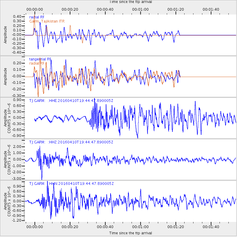
Signal To Noise
| Channel | StoN | STA | LTA |
| TJ:GARM: :HHZ:20160410T19:44:47.890005Z | 10.6402645 | 1.0890079E-6 | 1.0234782E-7 |
| TJ:GARM: :HHN:20160410T19:44:47.890005Z | 1.8121802 | 1.4184877E-7 | 7.82752E-8 |
| TJ:GARM: :HHE:20160410T19:44:47.890005Z | 3.6882114 | 3.349214E-7 | 9.0808626E-8 |
| Arrivals |
| Ps | |
| PpPs | |
| PsPs/PpSs | |


