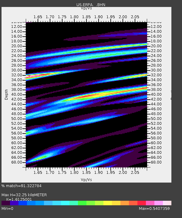
ERPA Erie, Pennsylvania, USA - Earthquake Result Viewer
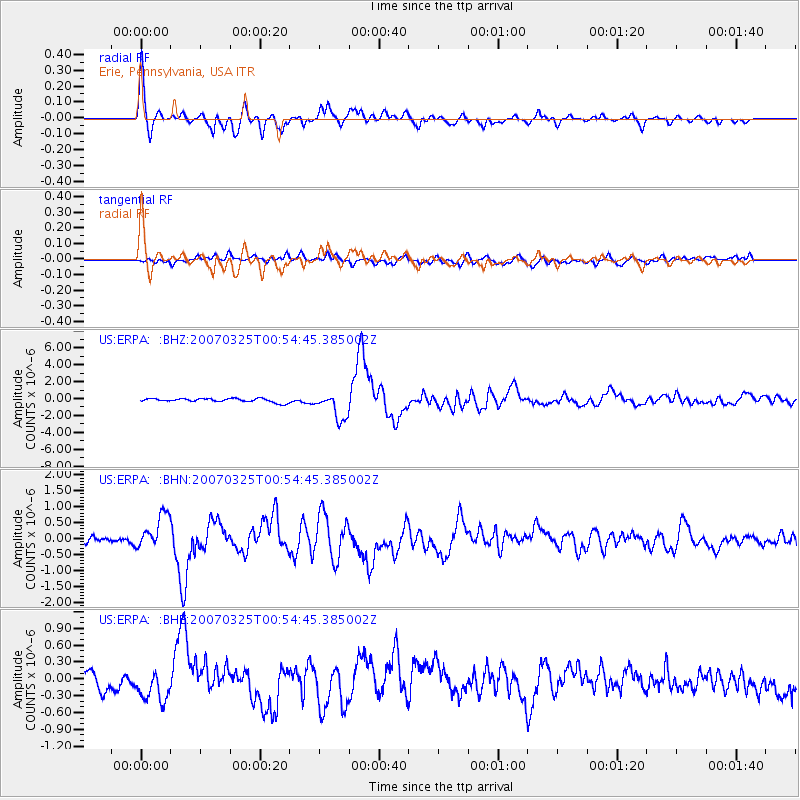
Earthquake location: Near West Coast Of Honshu, Japan
Earthquake latitude/longitude: 37.3/136.6
Earthquake time(UTC): 2007/03/25 (084) 00:41:57 GMT
Earthquake Depth: 8.0 km
Earthquake Magnitude: 6.1 MB, 6.8 MS, 6.7 MW, 6.6 MW
Earthquake Catalog/Contributor: WHDF/NEIC
Network: US United States National Seismic Network
Station: ERPA Erie, Pennsylvania, USA
Lat/Lon: 42.12 N/79.99 W
Elevation: 306 m
Distance: 94.2 deg
Az: 26.393 deg
Baz: 331.561 deg
Ray Param: 0.041107435
Estimated Moho Depth: 32.25 km
Estimated Crust Vp/Vs: 1.61
Assumed Crust Vp: 6.419 km/s
Estimated Crust Vs: 3.981 km/s
Estimated Crust Poisson's Ratio: 0.19
Radial Match: 91.322784 %
Radial Bump: 400
Transverse Match: 64.568245 %
Transverse Bump: 400
SOD ConfigId: 2564
Insert Time: 2010-03-05 01:10:53.997 +0000
GWidth: 2.5
Max Bumps: 400
Tol: 0.001

Signal To Noise

ChannelStoNSTALTA
US:ERPA: :BHN:20070325T00:54:45.385002Z4.75181965.3512423E-71.126146E-7
US:ERPA: :BHE:20070325T00:54:45.385002Z1.85420762.6451514E-71.426567E-7
US:ERPA: :BHZ:20070325T00:54:45.385002Z7.19662571.5738335E-62.1869049E-7
Arrivals
Ps3.1 SECOND
PpPs13 SECOND
PsPs/PpSs16 SECOND