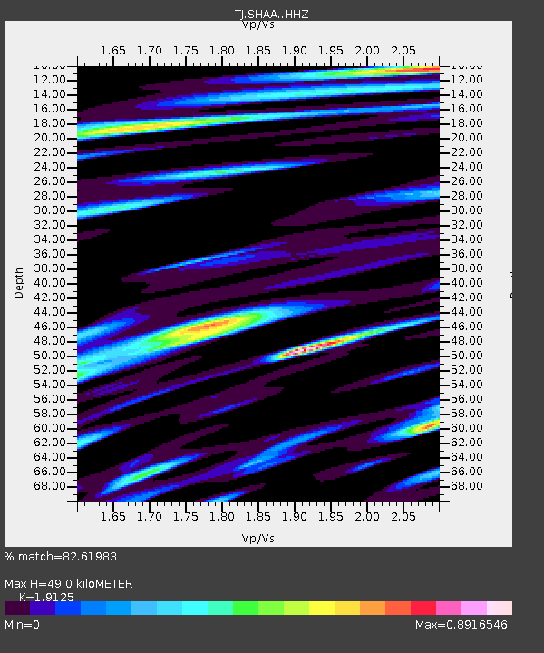
SHAA Shaartuz, Tajikistan - Earthquake Result Viewer

Earthquake location: Rat Islands, Aleutian Islands
Earthquake latitude/longitude: 51.1/179.5
Earthquake time(UTC): 2016/04/10 (101) 19:34:02 GMT
Earthquake Depth: 19 km
Earthquake Magnitude: 5.6 MWW, 5.3 ML, 5.4 MWB, 5.6 MWC, 5.7 ML
Earthquake Catalog/Contributor: NEIC PDE/NEIC COMCAT
Network: TJ Tajikistan National Seismic Network
Station: SHAA Shaartuz, Tajikistan
Lat/Lon: 37.56 N/68.12 E
Elevation: 868 m
Distance: 73.2 deg
Az: 309.408 deg
Baz: 37.786 deg
Ray Param: 0.053121597
Estimated Moho Depth: 49.0 km
Estimated Crust Vp/Vs: 1.91
Assumed Crust Vp: 6.213 km/s
Estimated Crust Vs: 3.249 km/s
Estimated Crust Poisson's Ratio: 0.31
Radial Match: 82.61983 %
Radial Bump: 400
Transverse Match: 82.08964 %
Transverse Bump: 400
SOD ConfigId: 7422571
Insert Time: 2019-04-22 04:55:30.160 +0000
GWidth: 2.5
Max Bumps: 400
Tol: 0.001

Signal To Noise

ChannelStoNSTALTA
TJ:SHAA: :HHZ:20160410T19:45:00.99999Z9.9845041.6226951E-61.6252136E-7
TJ:SHAA: :HHN:20160410T19:45:00.99999Z3.27516274.5393566E-71.3859942E-7
TJ:SHAA: :HHE:20160410T19:45:00.99999Z2.07219123.0771523E-71.4849749E-7
Arrivals
Ps7.4 SECOND
PpPs22 SECOND
PsPs/PpSs30 SECOND