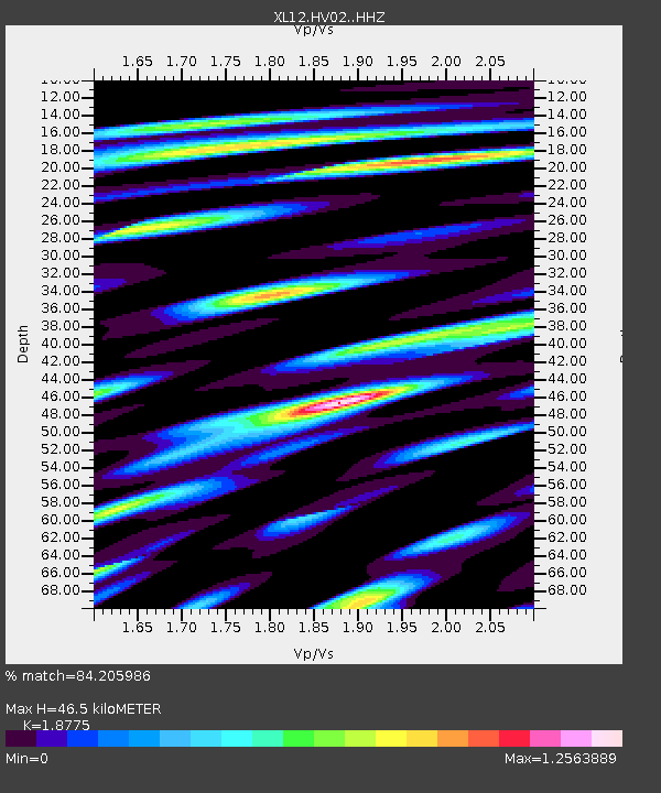
HV02 HV02 - Earthquake Result Viewer

Earthquake location: Rat Islands, Aleutian Islands
Earthquake latitude/longitude: 51.1/179.5
Earthquake time(UTC): 2016/04/10 (101) 19:34:02 GMT
Earthquake Depth: 19 km
Earthquake Magnitude: 5.6 MWW, 5.3 ML, 5.4 MWB, 5.6 MWC, 5.7 ML
Earthquake Catalog/Contributor: NEIC PDE/NEIC COMCAT
Network: XL Hangay Dome, Mongolia
Station: HV02 HV02
Lat/Lon: 51.15 N/99.35 E
Elevation: 1546 m
Distance: 47.9 deg
Az: 303.198 deg
Baz: 56.844 deg
Ray Param: 0.06968844
Estimated Moho Depth: 46.5 km
Estimated Crust Vp/Vs: 1.88
Assumed Crust Vp: 6.622 km/s
Estimated Crust Vs: 3.527 km/s
Estimated Crust Poisson's Ratio: 0.30
Radial Match: 84.205986 %
Radial Bump: 400
Transverse Match: 76.34622 %
Transverse Bump: 400
SOD ConfigId: 7422571
Insert Time: 2019-04-22 04:56:58.167 +0000
GWidth: 2.5
Max Bumps: 400
Tol: 0.001

Signal To Noise

ChannelStoNSTALTA
XL:HV02: :HHZ:20160410T19:42:08.339987Z13.1089693.4305825E-72.6169735E-8
XL:HV02: :HHN:20160410T19:42:08.339987Z6.1852241.9063637E-73.0821255E-8
XL:HV02: :HHE:20160410T19:42:08.339987Z4.96660661.7700847E-73.5639722E-8
Arrivals
Ps6.5 SECOND
PpPs19 SECOND
PsPs/PpSs26 SECOND