You are here: Home > Network List > GS - US Geological Survey Networks Stations List
> Station KAN11 Stewart Ranch, Harper County, KS, USA > Earthquake Result Viewer
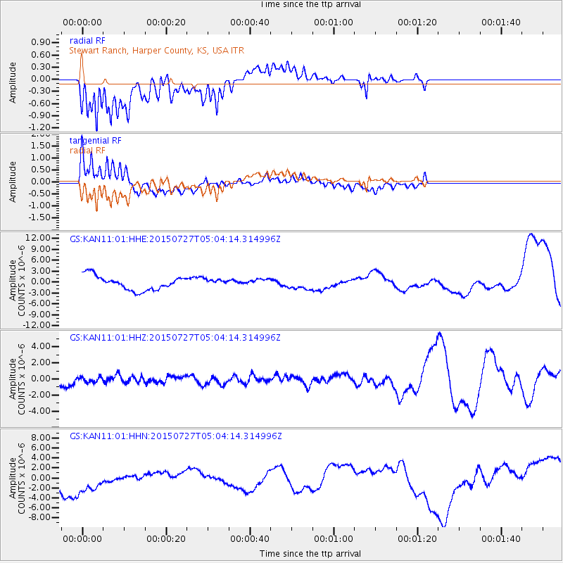
KAN11 Stewart Ranch, Harper County, KS, USA - Earthquake Result Viewer
*The percent match for this event was below the threshold and hence no stack was calculated.
| Earthquake location: |
Fox Islands, Aleutian Islands |
| Earthquake latitude/longitude: |
52.2/-169.5 |
| Earthquake time(UTC): |
2015/07/27 (208) 04:55:45 GMT |
| Earthquake Depth: |
21 km |
| Earthquake Magnitude: |
6.7 MS |
| Earthquake Catalog/Contributor: |
NEIC PDE/NEIC ALERT |
|
| Network: |
GS US Geological Survey Networks |
| Station: |
KAN11 Stewart Ranch, Harper County, KS, USA |
| Lat/Lon: |
37.21 N/97.91 W |
| Elevation: |
410 m |
|
| Distance: |
51.0 deg |
| Az: |
77.174 deg |
| Baz: |
311.199 deg |
| Ray Param: |
$rayparam |
*The percent match for this event was below the threshold and hence was not used in the summary stack. |
|
| Radial Match: |
61.174603 % |
| Radial Bump: |
400 |
| Transverse Match: |
82.18171 % |
| Transverse Bump: |
400 |
| SOD ConfigId: |
1085051 |
| Insert Time: |
2015-08-10 05:27:39.735 +0000 |
| GWidth: |
2.5 |
| Max Bumps: |
400 |
| Tol: |
0.001 |
|
Signal To Noise
| Channel | StoN | STA | LTA |
| GS:KAN11:01:HHZ:20150727T05:04:14.314996Z | 0.38739273 | 3.2750992E-7 | 8.454209E-7 |
| GS:KAN11:01:HHN:20150727T05:04:14.314996Z | 2.152088 | 3.2909388E-6 | 1.5291841E-6 |
| GS:KAN11:01:HHE:20150727T05:04:14.314996Z | 0.45689154 | 8.905434E-7 | 1.9491351E-6 |
| Arrivals |
| Ps | |
| PpPs | |
| PsPs/PpSs | |


