ERPA Erie, Pennsylvania, USA - Earthquake Result Viewer
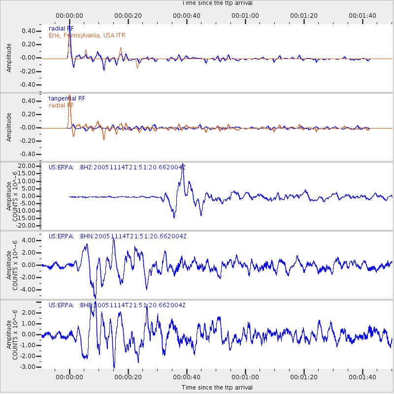
Earthquake location: Off East Coast Of Honshu, Japan
Earthquake latitude/longitude: 38.1/144.9
Earthquake time(UTC): 2005/11/14 (318) 21:38:51 GMT
Earthquake Depth: 11 km
Earthquake Magnitude: 6.7 MB, 6.8 MS, 7.0 MW, 6.9 MW
Earthquake Catalog/Contributor: WHDF/NEIC
Network: US United States National Seismic Network
Station: ERPA Erie, Pennsylvania, USA
Lat/Lon: 42.12 N/79.99 W
Elevation: 306 m
Distance: 90.3 deg
Az: 31.671 deg
Baz: 326.172 deg
Ray Param: 0.04168315
Estimated Moho Depth: 23.25 km
Estimated Crust Vp/Vs: 1.66
Assumed Crust Vp: 6.419 km/s
Estimated Crust Vs: 3.855 km/s
Estimated Crust Poisson's Ratio: 0.22
Radial Match: 97.42024 %
Radial Bump: 285
Transverse Match: 84.92212 %
Transverse Bump: 400
SOD ConfigId: 2448
Insert Time: 2010-03-05 01:11:36.006 +0000
GWidth: 2.5
Max Bumps: 400
Tol: 0.001

Signal To Noise

ChannelStoNSTALTA
US:ERPA: :BHN:20051114T21:51:20.662004Z4.5322098.73953E-71.9283156E-7
US:ERPA: :BHE:20051114T21:51:20.662004Z4.7505287.439048E-71.5659414E-7
US:ERPA: :BHZ:20051114T21:51:20.662004Z15.2500512.74839E-61.802217E-7
Arrivals
Ps2.5 SECOND
PpPs9.4 SECOND
PsPs/PpSs12 SECOND