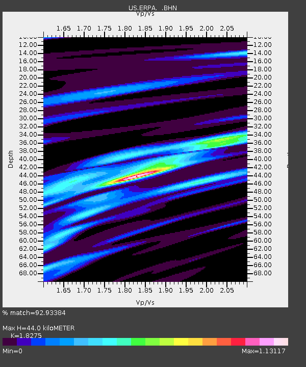
ERPA Erie, Pennsylvania, USA - Earthquake Result Viewer
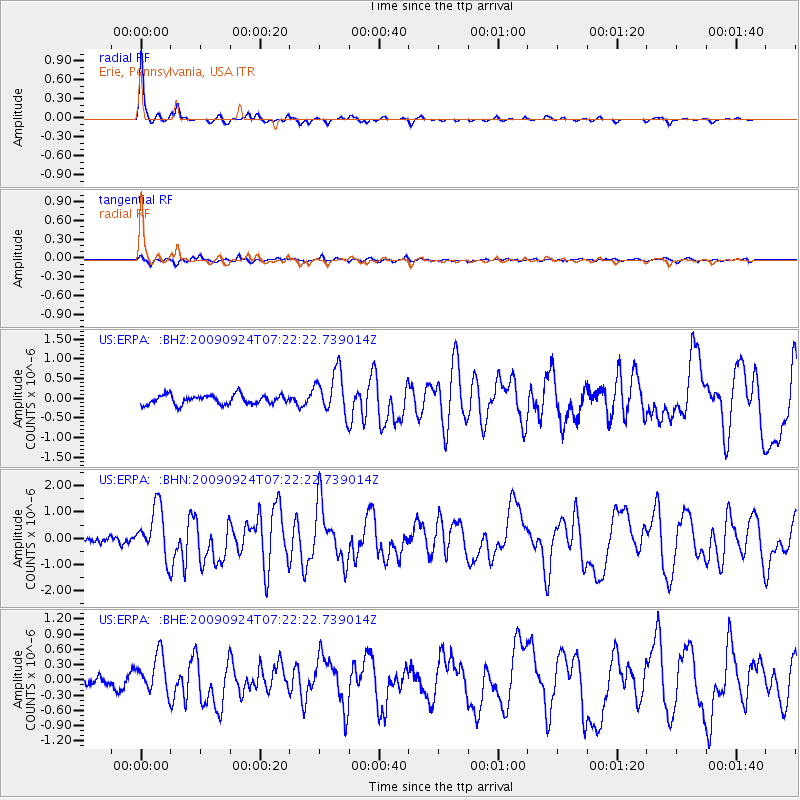
Earthquake location: Off Coast Of Jalisco, Mexico
Earthquake latitude/longitude: 18.8/-107.3
Earthquake time(UTC): 2009/09/24 (267) 07:16:19 GMT
Earthquake Depth: 10 km
Earthquake Magnitude: 5.8 MB, 6.2 MS, 6.3 MW, 6.3 MW
Earthquake Catalog/Contributor: WHDF/NEIC
Network: US United States National Seismic Network
Station: ERPA Erie, Pennsylvania, USA
Lat/Lon: 42.12 N/79.99 W
Elevation: 306 m
Distance: 32.8 deg
Az: 39.081 deg
Baz: 233.377 deg
Ray Param: 0.07848043
Estimated Moho Depth: 44.0 km
Estimated Crust Vp/Vs: 1.83
Assumed Crust Vp: 6.419 km/s
Estimated Crust Vs: 3.513 km/s
Estimated Crust Poisson's Ratio: 0.29
Radial Match: 92.93384 %
Radial Bump: 223
Transverse Match: 79.92271 %
Transverse Bump: 400
SOD ConfigId: 2622
Insert Time: 2010-03-05 01:11:40.253 +0000
GWidth: 2.5
Max Bumps: 400
Tol: 0.001

Signal To Noise

ChannelStoNSTALTA
US:ERPA: :BHN:20090924T07:22:22.739014Z7.61101159.639302E-71.2664943E-7
US:ERPA: :BHE:20090924T07:22:22.739014Z3.26462273.791782E-71.1614763E-7
US:ERPA: :BHZ:20090924T07:22:22.739014Z4.6623895.474169E-71.17411254E-7
Arrivals
Ps6.1 SECOND
PpPs18 SECOND
PsPs/PpSs24 SECOND