You are here: Home > Network List > CI - Caltech Regional Seismic Network Stations List
> Station MPM Manuel Prospect Mine, California, USA > Earthquake Result Viewer
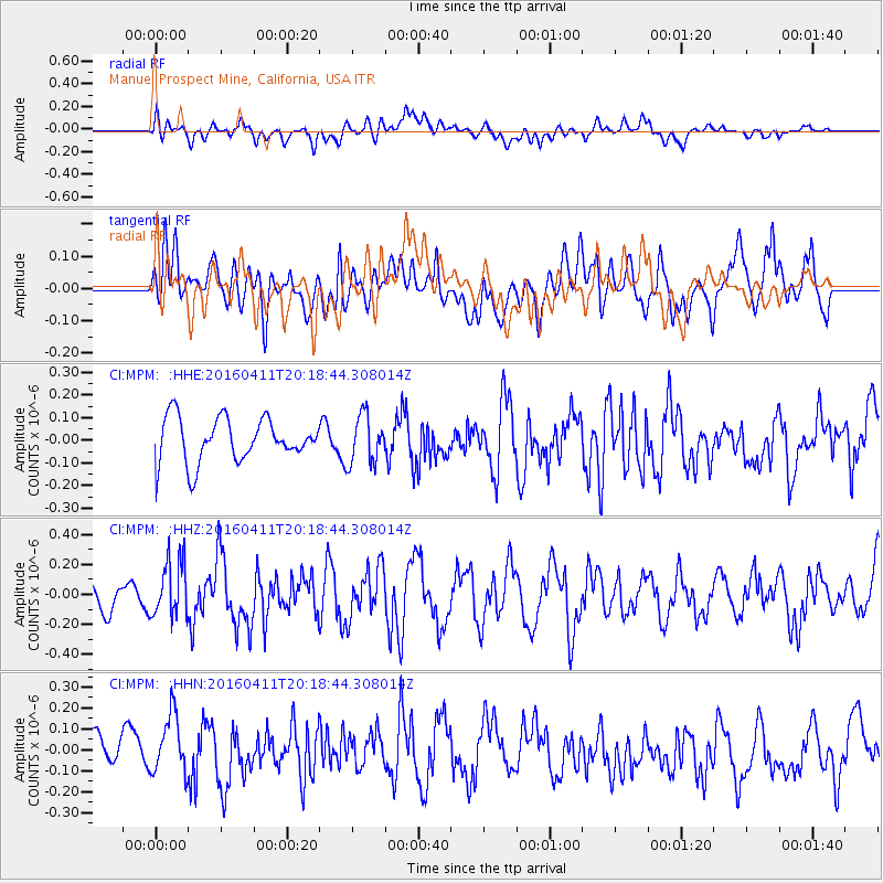
MPM Manuel Prospect Mine, California, USA - Earthquake Result Viewer
*The percent match for this event was below the threshold and hence no stack was calculated.
| Earthquake location: |
Rat Islands, Aleutian Islands |
| Earthquake latitude/longitude: |
51.8/176.6 |
| Earthquake time(UTC): |
2016/04/11 (102) 20:10:35 GMT |
| Earthquake Depth: |
22 km |
| Earthquake Magnitude: |
5.6 MB, 5.5 MB, 5.6 MI |
| Earthquake Catalog/Contributor: |
NEIC PDE/NEIC COMCAT |
|
| Network: |
CI Caltech Regional Seismic Network |
| Station: |
MPM Manuel Prospect Mine, California, USA |
| Lat/Lon: |
36.06 N/117.49 W |
| Elevation: |
185 m |
|
| Distance: |
48.3 deg |
| Az: |
82.0 deg |
| Baz: |
310.696 deg |
| Ray Param: |
$rayparam |
*The percent match for this event was below the threshold and hence was not used in the summary stack. |
|
| Radial Match: |
38.74993 % |
| Radial Bump: |
400 |
| Transverse Match: |
56.265064 % |
| Transverse Bump: |
400 |
| SOD ConfigId: |
7422571 |
| Insert Time: |
2019-04-22 05:04:40.202 +0000 |
| GWidth: |
2.5 |
| Max Bumps: |
400 |
| Tol: |
0.001 |
|
Signal To Noise
| Channel | StoN | STA | LTA |
| CI:MPM: :HHZ:20160411T20:18:44.308014Z | 2.3984442 | 1.8969129E-7 | 7.908931E-8 |
| CI:MPM: :HHN:20160411T20:18:44.308014Z | 1.7051969 | 1.4259224E-7 | 8.362216E-8 |
| CI:MPM: :HHE:20160411T20:18:44.308014Z | 1.1018038 | 1.0593227E-7 | 9.614441E-8 |
| Arrivals |
| Ps | |
| PpPs | |
| PsPs/PpSs | |


